A Complete Field Record of the Anegawa Battlefield Signboards|Nos. 1–15, Historic Site Data, and Panoramic Photos Included
This page is the only guide that has personally verified and organized all 15 numbered signboards installed across the Anegawa Battlefield in Nagahama, Shiga Prefecture. Because I could not find a page online that clearly arranged all 15 signboards in one place, I walked the battlefield myself and recorded every spot.
For each signboard, you will find historic site data, highlights, trivia, access information, maps, and 360-degree panoramic photos in an accordion format. Please click the “Open historic site data, highlights, and map” banner for each spot to get a feel for the site. For an overview of the Anegawa Battlefield, access details, and an explanation of the main highlights, see the Anegawa Battlefield Highlights and Walking Guide as well.
- Map of All 15 Signboards
- All Signboards
- Signboard No. 1: Nobunaga’s Headquarters and Ieyasu’s Headquarters
- Signboard No. 2: The Grave of Endo Naotsune
- Signboard No. 3: The Ryugahana Enclosure Group
- Signboard No. 4: Oda Nobunaga and Jinkui no Yanagi
- Signboard No. 5: Tokugawa Ieyasu and Okayama
- Signboards No. 6 and No. 15: Ishida Mitsunari’s Residence and the Yokoyama Hills
- Signboard No. 7: Chihara and the Mitamura Residence
- Signboard No. 8: Anegawa Battlefield
- Signboard No. 9: Chigawa and the Historic Sites of Nomura
- Signboard No. 10: Azai Nagamasa and Jindono
- Signboard No. 11: National Historic Site, Mitamura Residence Site
- Signboard No. 12: The Tombs of the Seventy Warriors
- Signboard No. 13: Oyoriyama
- Signboard No. 14: Kozaka Clan Residence Site
- Frequently Asked Questions
Map of All 15 Signboards
All Signboards
Signboard No. 1: Nobunaga’s Headquarters and Ieyasu’s Headquarters
The starting point for understanding the troop formations at the Battle of Anegawa
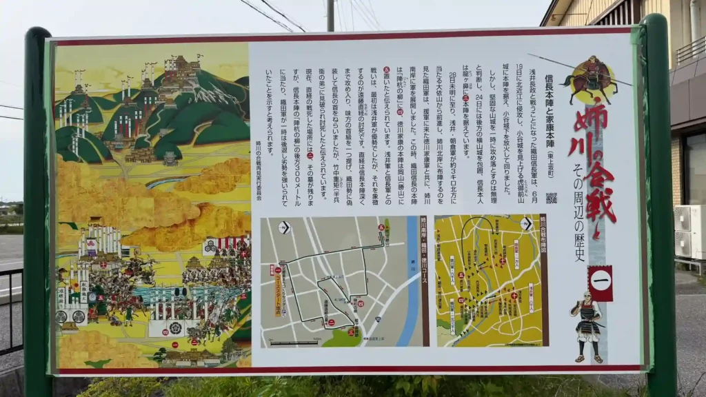
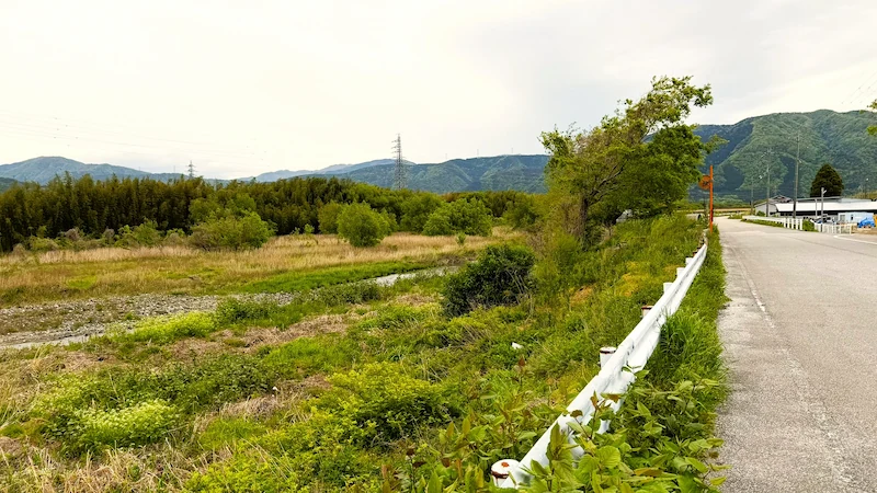
The “Nobunaga’s Headquarters and Ieyasu’s Headquarters” signboard, located in the parking lot of the Kitagori Community Development Center, is the ideal starting point for reading the formations of the Battle of Anegawa. On June 28, 1570, Oda Nobunaga is known to have placed his headquarters at Jinkui no Yanagi on the south bank of the Anegawa River, while Tokugawa Ieyasu set up his headquarters at Okayama, a small hill to the northwest.
📜 Historic Site Data
| Structure / Features | An informational signboard about the Battle of Anegawa installed in the parking lot of the Kitagori Community Development Center. It shows the spatial relationship between Oda Nobunaga’s headquarters at Jinkui no Yanagi and Tokugawa Ieyasu’s headquarters at Okayama. |
|---|---|
| Cultural Property Designation | No information available |
| Notes | On the day of the Battle of Anegawa, Nobunaga’s headquarters were at Jinkui no Yanagi, while Ieyasu’s headquarters were at Okayama. |
👀 Highlights
- Nobunaga’s headquarters, “Jinkui no Yanagi”: A confirmed site on the south bank of the Anegawa where Oda Nobunaga placed his headquarters, offering clues to how the Oda army moved that day.
- Ieyasu’s headquarters, “Okayama”: A small hill about 800 meters northwest of Jinkui no Yanagi, known as the place where Tokugawa Ieyasu established his headquarters.
- Starting point for the battlefield walk: With parking available, this is the best place to understand the overall troop layout before walking to the individual sites.
📌 Trivia
- From Okayama to “Katsuyama”: Okayama, where Tokugawa Ieyasu is said to have set up his headquarters, came to be called “Katsuyama,” or “Victory Mountain,” in the Edo period because of Ieyasu’s victory in the battle.
🗺 Address
976-7 Higashikozaka-cho, Nagahama City, Shiga Prefecture
🚶 Access
About 15–20 minutes by car from JR Nagahama Station. The Kitagori Community Development Center parking lot is commonly used as the starting point for touring the battlefield.
🚗 Parking
Kitagori Community Development Center parking lot available (free; please confirm in advance)
⏳ Suggested Visit Time
Quick visit: about 5 minutes / In-depth visit: about 15 minutes
💴 Admission
Free
Panoramic Photo: Nobunaga’s Headquarters and Ieyasu’s Headquarters
Signboard No. 2: The Grave of Endo Naotsune
A quiet rural grave preserving the final moments of a senior Azai retainer who approached Nobunaga’s headquarters
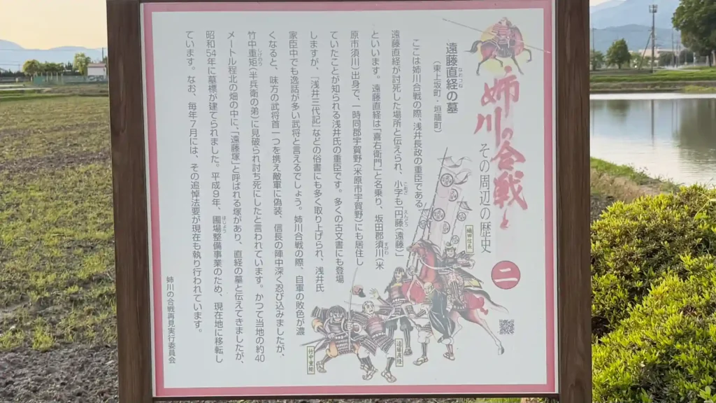
Standing in a corner of the countryside, the grave of Endo Naotsune is a small historic site that preserves the story of a senior retainer who served Azai Nagamasa at the Battle of Anegawa. During the 1570 battle, as the Azai army’s defeat became increasingly likely, Endo Naotsune is said to have disguised himself as an Oda soldier and tried to approach Nobunaga’s headquarters. Today, a grave marker and an explanatory sign stand at the site.
📜 Historic Site Data
| Construction Year | The grave marker was erected in 1979. |
|---|---|
| Repairs / Relocation | Moved to its present location in 1997 due to a farmland improvement project. |
| Cultural Property Designation | Not designated |
| Notes | About 40 meters north of the present site, there was once a mound called Endo-zuka, traditionally believed to be Naotsune’s grave. |
👀 Highlights
- Grave marker of Endo Naotsune: A memorial marker for Endo Naotsune, who entered the Battle of Anegawa as a senior retainer of Azai Nagamasa.
- Seasonal memorial service: A memorial service is held every July.
📌 Trivia
- A desperate approach to Nobunaga’s headquarters: Endo Naotsune is said to have carried the head of an ally, pretended to be an Oda soldier, and attempted to get close to Nobunaga’s headquarters.
- A relocated grave site: The present grave was moved from the former Endo-zuka due to farmland improvement work.
🗺 Address
565 Kaigome-cho, Nagahama City, Shiga Prefecture
🚶 Access
Within walking distance of the Kitagori Community Development Center (Signboard No. 1).
🚗 Parking
No dedicated parking. Visit on foot from the Kitagori Community Development Center parking lot.
⏳ Suggested Visit Time
Quick visit: about 5 minutes / In-depth visit: about 15 minutes
💴 Admission
Free
Panoramic Photo: The Grave of Endo Naotsune
Signboard No. 3: The Ryugahana Enclosure Group
A high point at the northern end of the Yokoyama Hills, where an ancient burial mound and a Sengoku military position overlap
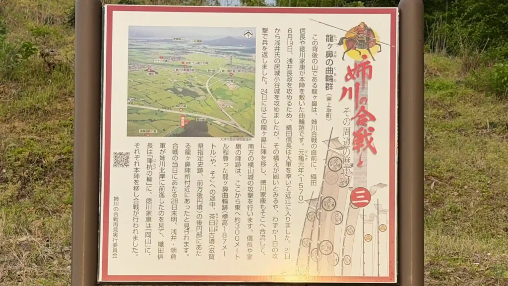
The signboard for the “Ryugahana Enclosure Group,” standing in front of Chausuyama Kofun, is an important clue for tracing the movements of the Oda–Tokugawa allied forces immediately before the Battle of Anegawa. Ryugahana, at the northern end of the Yokoyama Hills, overlooks the Anegawa Battlefield and is said to be where Oda Nobunaga and Tokugawa Ieyasu placed their positions during the attack on Yokoyama Castle. At your feet remains Chausuyama Kofun, a keyhole-shaped burial mound that makes use of the natural hill terrain.
📜 Historic Site Data
| Structure / Features | Remains of enclosures at Ryugahana on the northern end of the Yokoyama Hills. Nearby Chausuyama Kofun is a keyhole-shaped burial mound built using the natural hill. |
|---|---|
| Loss / Damage | The top of the rear circular portion of Chausuyama Kofun was cut down during military exercises in the early Showa period. |
| Cultural Property Designation | Chausuyama Kofun is a Shiga Prefecture-designated historic site. |
| Notes | In June 1570, Oda Nobunaga and Tokugawa Ieyasu are described as having placed their positions here during the attack on Yokoyama Castle. |
👀 Highlights
- Ryugahana enclosure remains: A hilltop military position described as the place where Nobunaga and Ieyasu set up camp immediately before the Battle of Anegawa.
- Chausuyama Kofun: A keyhole-shaped burial mound using the natural terrain overlooking the Anegawa Battlefield.
- View: From the northern end of the Yokoyama Hills, you can look out over the Anegawa basin where the battle unfolded.
📌 Trivia
- Haniwa fragments: Numerous fragments of cylindrical haniwa have been found near the entrance to the rear circular mound of Chausuyama Kofun.
🗺 Address
Higashikozaka-cho, Nagahama City, Shiga Prefecture
🚶 Access
Reach the site on foot or by car from the Kitagori Community Development Center. It is located at the northern end of the Yokoyama Hills and requires climbing a hill route.
🚗 Parking
No dedicated parking (please confirm in advance)
⏳ Suggested Visit Time
Quick visit: about 10 minutes / In-depth visit: about 30 minutes
💴 Admission
Free
Panoramic Photo: The Ryugahana Enclosure Group
Signboard No. 4: Oda Nobunaga and Jinkui no Yanagi
A symbol of Nobunaga’s headquarters, standing beside the willow where he is said to have hung his war drum
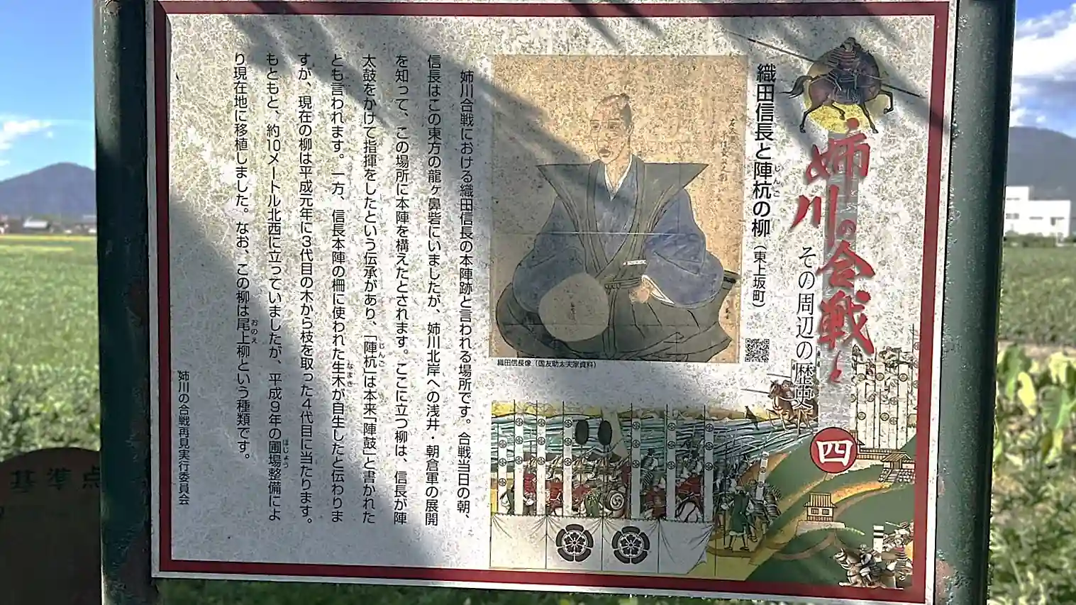
Jinkui no Yanagi is traditionally known as the site of Oda Nobunaga’s headquarters during the Battle of Anegawa. A local tradition says that Nobunaga hung his war drum from the willow and directed the battle from there. The current tree is the fourth generation, grown in 1989 from a branch of the third-generation willow. Standing before this single willow in the open countryside, you can quietly sense the strategic position from which Nobunaga looked across the battlefield.
📜 Historic Site Data
| Structure / Features | A willow traditionally associated with Oda Nobunaga’s headquarters during the Battle of Anegawa. It is said that Nobunaga hung his war drum here and commanded the battle. |
|---|---|
| Repairs / Restoration | The current willow is the fourth generation, taken from a branch of the third-generation tree in 1989. |
| Cultural Property Designation | No information available |
👀 Highlights
- Jinkui no Yanagi: A willow connected to the tradition that Oda Nobunaga hung his war drum here and directed the battle.
- The fourth-generation willow: The present tree has been passed down through successive generations, making it fascinating as a living continuation of local memory.
📌 Trivia
- Origin of the fourth-generation tree: The current willow was grown in 1989 from a branch of the third-generation willow.
🗺 Address
Higashikozaka-cho, Nagahama City, Shiga Prefecture
🚶 Access
Within walking distance of the Kitagori Community Development Center. A single willow stands in the fields; follow the local signboards as you go.
🚗 Parking
No dedicated parking (please confirm in advance)
⏳ Suggested Visit Time
Quick visit: about 5 minutes / In-depth visit: about 15 minutes
💴 Admission
Free
Panoramic Photo: Oda Nobunaga and Jinkui no Yanagi
Signboard No. 5: Tokugawa Ieyasu and Okayama
The hill of victory, “Okayama”—a quiet historic site where Ieyasu’s headquarters and Nagareoka Shrine overlap
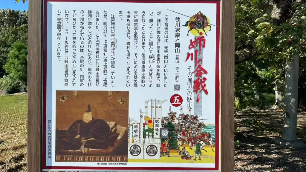
The “Tokugawa Ieyasu and Okayama” signboard in front of Kozaka Shrine marks the entrance to the site associated with Tokugawa Ieyasu’s headquarters at the Battle of Anegawa. On June 28, 1570, Ieyasu placed his headquarters at Okayama, a small hill about 800 meters northwest of Jinkui no Yanagi. After the battle, the site came to be known in the Edo period as Katsuyama, or “Victory Mountain,” in honor of Ieyasu’s victory.
📜 Historic Site Data
| Structure / Features | A small hill in Higashikozaka-cho, traditionally regarded as Tokugawa Ieyasu’s headquarters during the Battle of Anegawa. It was called Katsuyama in the Edo period. |
|---|---|
| Repairs / Relocation | In 1908, Nagareoka Shrine was moved to Kozaka Shrine within the Higashikozaka settlement. |
| Cultural Property Designation | Not designated |
| Notes | Kozaka Shrine preserves a gilt lantern said to have been dedicated by Oda Nobunaga in gratitude for victory at the Battle of Anegawa in 1570. |
👀 Highlights
- Okayama (Katsuyama): The small hill where Tokugawa Ieyasu set up his headquarters at Anegawa. Visiting it alongside Jinkui no Yanagi makes the battle formation easier to grasp.
- Gilt lantern at Kozaka Shrine: A lantern said to have been offered by Oda Nobunaga in thanks for victory at Anegawa remains at the shrine.
📌 Trivia
- From Okayama to “Katsuyama”: Because Ieyasu commanded from this site and won the battle, Okayama came to be called Katsuyama in the Edo period.
- A name preserved in Omi Province maps: Some Edo-period maps of Omi Province record the names Katsuyama and Nagareoka Shrine.
🗺 Address
1302 Higashikozaka-cho, Nagahama City, Shiga Prefecture
🚶 Access
Use Kozaka Shrine as your landmark. The site is about 800 meters northwest of Signboard No. 4, Jinkui no Yanagi.
🚗 Parking
Parking space available near Kozaka Shrine (please confirm in advance)
⏳ Suggested Visit Time
Quick visit: about 10 minutes / In-depth visit: about 20 minutes
💴 Admission
Free
Panoramic Photo: Tokugawa Ieyasu and Okayama
Signboards No. 6 and No. 15: Ishida Mitsunari’s Residence and the Yokoyama Hills
The birthplace of Ishida Mitsunari, the brilliant Toyotomi strategist, and the hills overlooking the battlefield
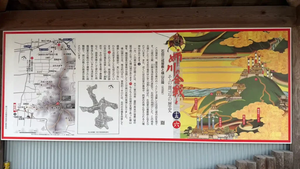
The “Ishida Mitsunari’s Residence and the Yokoyama Hills” signboard, standing in front of the site of Ishida Jibu-shosuke Mitsunari’s residence, connects the Yokoyama Hills—overlooking the battlefield from east to west—with the roots of Ishida Mitsunari, who would later support the Toyotomi regime. Ishida Hall stands on the site of the residence where Mitsunari was born. Outside the hall are a stone monument inscribed “Birthplace of Ishida Jibu-shosuke” and a statue of Mitsunari.
📜 Historic Site Data
| Structure / Features | Ishida Hall stands on the site of Ishida Mitsunari’s family home. Outside the building are a birthplace monument and a statue of Mitsunari, and inside is an exhibition room related to him. |
|---|---|
| Cultural Property Designation | No information available |
| Notes | Ishida Mitsunari was born in 1560 in Ishida Village, Sakata District, Omi Province, present-day Ishida-cho, Nagahama City, Shiga Prefecture. Behind the Ishida Hall building, traces of a moat connected to the Ishida family residence are said to remain. |
👀 Highlights
- Birthplace monument of Ishida Jibu-shosuke: A stone monument marking the birthplace of Ishida Mitsunari and the heart of any visit to sites connected with him.
- Connection to the Yokoyama Hills: A hiking route leads from the residence area toward Yokoyama, allowing visitors to experience the terrain that links Mitsunari’s hometown with the ruins of Yokoyama Castle.
- Ishida Mitsunari Festival: Around Ishida Hall, exhibitions and local events connected to Mitsunari are held in conjunction with the Ishida Mitsunari Festival.
📌 Trivia
- Yokoyama Castle and Nobunaga’s base: After the Battle of Anegawa, Yokoyama Castle became a base for Oda Nobunaga’s forces and played an important role in the campaign against Odani Castle.
- Mitsunari and the Toyotomi regime: Ishida Mitsunari was born in Ishida Village, later served Toyotomi Hideyoshi, and became one of the Five Commissioners of the Toyotomi government.
🗺 Address
576 Jibu, Ishida-cho, Nagahama City, Shiga Prefecture
🚶 Access
About 15–20 minutes by car from JR Nagahama Station. It can also be used as an entry point for the Yokoyama Hills hiking route.
🚗 Parking
Parking space available near Ishida Hall (please confirm in advance)
⏳ Suggested Visit Time
Quick visit: about 15 minutes / In-depth visit: about 45 minutes, including the exhibition room
💴 Admission
Free. However, Ishida Hall is not always open, so checking opening days and availability in advance is recommended.
Panoramic Photo: Ishida Mitsunari’s Residence and the Yokoyama Hills
Signboard No. 7: Chihara and the Mitamura Residence
A historic zone on the north bank of the Anegawa, where the fierce battlefield of Chihara stands beside medieval residence remains
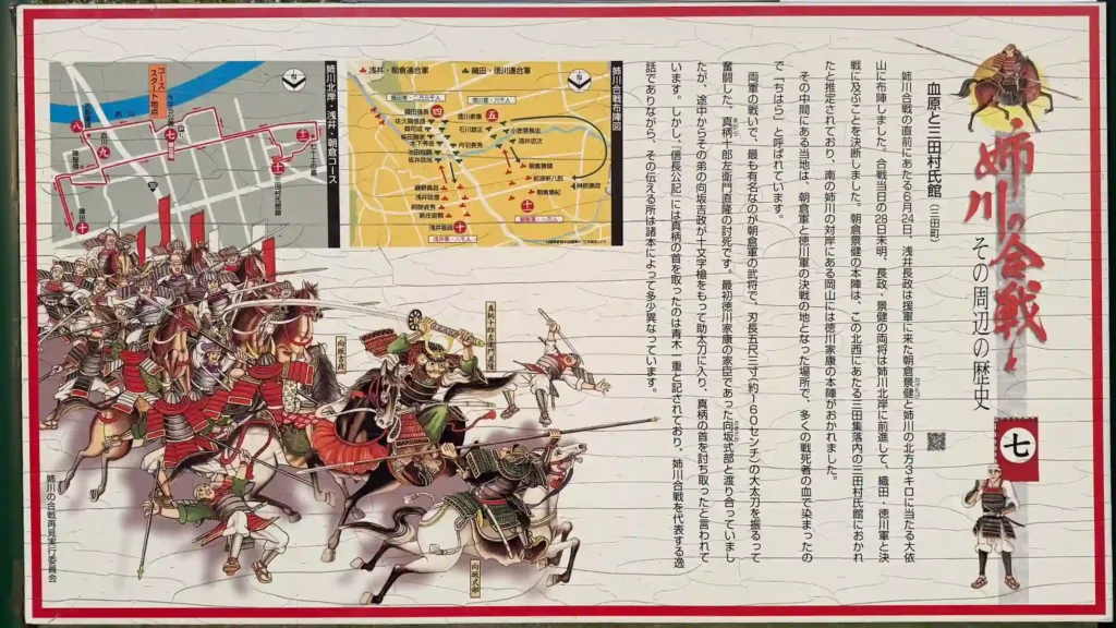
The “Chihara and the Mitamura Residence” signboard inside Chihara Park serves as a guide to the north-bank side of the Battle of Anegawa. The place-name Chihara, or “Field of Blood,” remains from the fierce fighting on June 28, 1570. Nearby, the Mitamura Residence Site is where Asakura Kagetake’s forces placed their headquarters during the battle. Earthen ramparts and moat remains can still be seen today, allowing visitors to walk through a quiet rural setting where military formations and a medieval flatland residence overlap.
📜 Historic Site Data
| Construction Year | The Mitamura Residence Site dates to the late 15th to early 16th century. |
|---|---|
| Structure / Features | Chihara Park was developed on the site regarded as one of the fiercest areas of the Battle of Anegawa. The Mitamura Residence Site is a flatland fortified residence enclosed by earthen ramparts around a roughly 60-meter-square enclosure, with ramparts, moat remains, and an entrance still visible. |
| Cultural Property Designation | The Mitamura Residence Site is part of the nationally designated historic site “Northern Omi Fortified Residence Sites: Shimosaka Residence Site and Mitamura Residence Site.” |
| Notes | During the Battle of Anegawa, this area is known as the place where Asakura Kagetake’s forces placed their headquarters. |
👀 Highlights
- Chihara Park: A park developed at Chihara, regarded as a fierce battlefield of the Battle of Anegawa, where you can trace the memory of the battle amid quiet water and farmland.
- Mitamura Residence Site: A nationally designated historic site said to have served as the headquarters of Asakura Kagetake’s forces, where ramparts and moat remains reveal the defensive character of a medieval flatland residence.
- Spring scenery: In spring, you can walk the battlefield area while taking in cherry blossoms and green wheat fields along the Anegawa.
📌 Trivia
- Magara Jurozaemon’s fierce fighting: Chihara is known as the place where Asakura-side warrior Magara Jurozaemon Naotaka fought fiercely with a massive sword.
- Asakura Kagetake’s headquarters: The Mitamura Residence Site is traditionally connected with the headquarters of Asakura Kagetake’s forces, who faced Tokugawa Ieyasu’s army.
🗺 Address
Mita-cho, Nagahama City, Shiga Prefecture
🚶 Access
North-bank battlefield area near Mita-cho. It can be visited together with the Mitamura Residence Site.
🚗 Parking
No dedicated parking (please confirm in advance)
⏳ Suggested Visit Time
Quick visit: about 10 minutes / In-depth visit: about 30 minutes
💴 Admission
Free
Panoramic Photo: Chihara and the Mitamura Residence
Signboard No. 8: Anegawa Battlefield
A memorial beside Nomura Bridge—the heart of the Battle of Anegawa
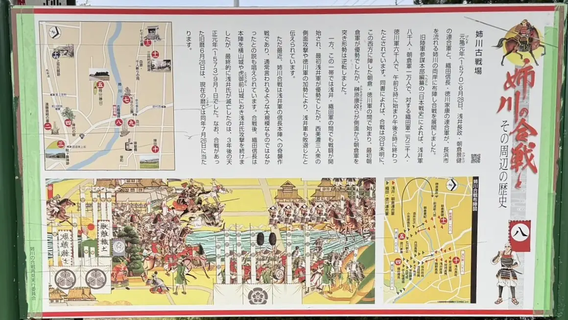
The “Anegawa Battlefield” signboard, standing beside the battlefield stone monument, explains the central area of the battle fought near Nomura Bridge. Today, a memorial for the war dead stands by the bridge, while nearby sites such as Jinkui no Yanagi, the Mitamura Residence Site, and Chihara preserve memories of the battle. As you look at the monument amid the sound of the river and the surrounding fields, the weight of this clash—one that reshaped the power map of the Sengoku period—quietly comes into focus.
📜 Historic Site Data
| Structure / Features | Battlefield remains near Nomura Bridge on the Anegawa River. A memorial monument for the war dead, a battlefield stone marker, and an explanatory signboard are installed here. |
|---|---|
| Cultural Property Designation | Nagahama City-designated historic site “Anegawa Battlefield Site.” Designated May 1, 1979. |
| Notes | Located in Nomura-cho and Mita-cho, Nagahama City, Shiga Prefecture. |
👀 Highlights
- Memorial for the war dead: A monument honoring those who lost their lives at the Battle of Anegawa, serving as the central landmark of the battlefield site.
- Battlefield landscape near Nomura Bridge: The terrain where both armies faced each other across the Anegawa River can be understood on site, making it easier to imagine the positions of the Nobunaga–Ieyasu side and the Azai–Asakura side.
📌 Trivia
- Broken alliance and confrontation: The Battle of Anegawa was fought after the alliance between Azai Nagamasa and Oda Nobunaga collapsed, bringing the Azai–Asakura forces into conflict with the Oda–Tokugawa alliance.
🗺 Address
Nomura-cho and Mita-cho, Nagahama City, Shiga Prefecture
🚶 Access
About 20 minutes by car from JR Nagahama Station. Nomura Bridge is the main landmark.
🚗 Parking
Parking space near Nomura Bridge (please confirm in advance)
⏳ Suggested Visit Time
Quick visit: about 10 minutes / In-depth visit: about 30 minutes
💴 Admission
Free
Panoramic Photo: Anegawa Battlefield
Signboard No. 9: Chigawa and the Historic Sites of Nomura
The memory of Chigawa, erased by farmland improvement—place-names that preserve the retreat of the Azai army
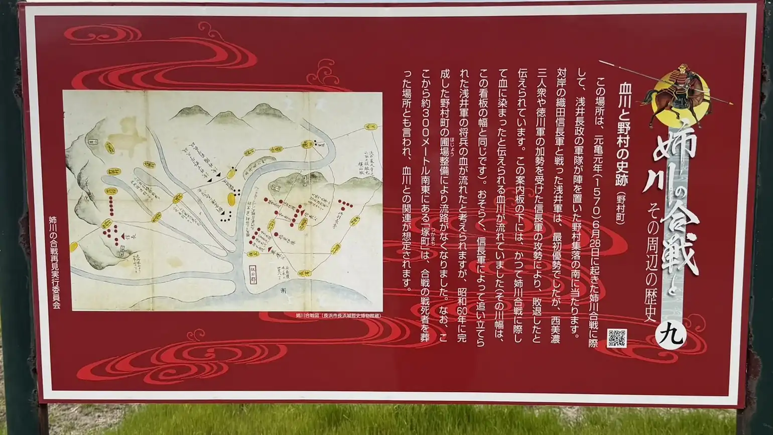
The “Chigawa and the Historic Sites of Nomura” signboard stands on the south side of the Nomura settlement, where Azai Nagamasa’s army took position during the Battle of Anegawa. Near the sign once flowed Chigawa, a stream said to have been stained with blood from the battle, but its channel disappeared as a result of the Nomura-cho farmland improvement project completed in 1985. Although the river itself can no longer be seen, the place-name and signboard quietly preserve the battle memory embedded across Nomura.
📜 Historic Site Data
| Structure / Features | A historic site signboard on the south side of the Nomura settlement, where Azai Nagamasa’s army was positioned. It explains the former Chigawa stream that once flowed nearby. |
|---|---|
| Repairs / Changes | The channel of Chigawa disappeared as a result of the farmland improvement project completed in Nomura-cho in 1985. |
| Cultural Property Designation | No information available |
| Notes | The explanatory sign notes that the former width of Chigawa was the same as the width of the signboard. |
👀 Highlights
- A river width equal to the signboard: The sign explains that the former width of Chigawa was the same as the width of the signboard, allowing visitors to grasp its scale.
- The memory of a vanished stream: Even though the river channel no longer exists, the place-name preserves the battle memory.
📌 Trivia
- A battlefield preserved in place-names: Chigawa, literally “Blood River,” is one of the place-names that conveys the intensity of the Battle of Anegawa.
🗺 Address
Nomura-cho, Nagahama City, Shiga Prefecture
🚶 Access
Located near the Anegawa Battlefield site around Nomura Bridge; accessible on foot from the bridge area.
🚗 Parking
Small parking spaces may be available near Nomura Bridge, but traffic restrictions may be in effect. Please check local restrictions and detour routes in advance.
⏳ Suggested Visit Time
Quick visit: about 5 minutes / In-depth visit: about 15 minutes
💴 Admission
Free
Panoramic Photo: Chigawa and the Historic Sites of Nomura
Signboard No. 10: Azai Nagamasa and Jindono
The lost Jinden hill, erased by farmland improvement—reading the traditional site of the Azai headquarters
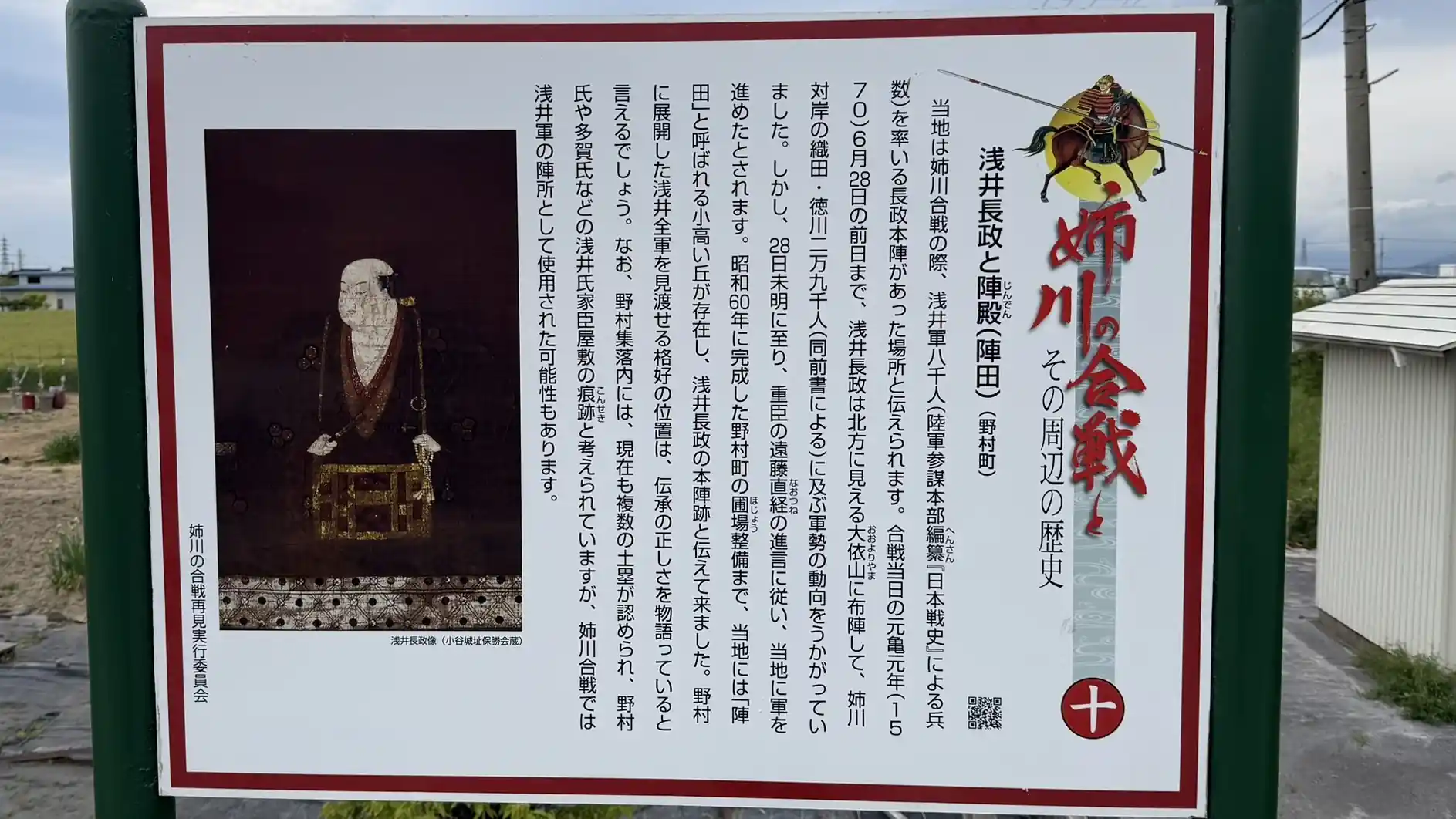
The “Azai Nagamasa and Jindono” signboard preserves the tradition of the Azai army’s headquarters. In the past, a small rise called Jinden stood in this area and was said to have been the headquarters of Azai Nagamasa. Although the historic terrain has disappeared due to farmland improvement, looking out toward the Anegawa from the area around the stone marker and signboard lets you sense the distance between the opposing Azai and Oda forces.
📜 Historic Site Data
| Structure / Features | A traditional site associated with Azai Nagamasa’s headquarters. The small hill known as Jinden once stood here but has been lost. |
|---|---|
| Loss / Changes | Before the 1985 farmland improvement project, a small raised area called Jinden existed here. |
| Cultural Property Designation | No information available |
| Notes | The site is beside the stone monument at the Anegawa Battlefield site, near Nomura Bridge. |
👀 Highlights
- Traditional Azai headquarters site: A place associated with Azai Nagamasa’s command position at the Battle of Anegawa.
- Earthen ramparts in the Nomura settlement: Several earthen ramparts thought to be related to residences of Azai retainers remain within the settlement.
📌 Trivia
- Advance from Oyoriyama on the eve of battle: Azai Nagamasa is said to have been positioned at Oyoriyama until the day before the battle and to have advanced toward Nomura in the early hours of the battle day.
- Farmland improvement in 1985: Before the 1985 project, a small hill known as Jinden existed here.
🗺 Address
Nomura-cho, Nagahama City, Shiga Prefecture
🚶 Access
Located beside the stone monument at the Anegawa Battlefield site (Signboard No. 8). Accessible on foot from the Nomura Bridge area.
🚗 Parking
Small parking spaces may be available near Nomura Bridge, but traffic restrictions may be in effect. Please confirm local restrictions and detour routes before arriving by car.
⏳ Suggested Visit Time
Quick visit: about 5 minutes / In-depth visit: about 15 minutes
💴 Admission
Free
Panoramic Photo: Azai Nagamasa and Jindono
Signboard No. 11: National Historic Site, Mitamura Residence Site
A medieval fortified residence where Asakura Kagetake placed his headquarters—an Anegawa north-bank national historic site with surviving ramparts and moat remains
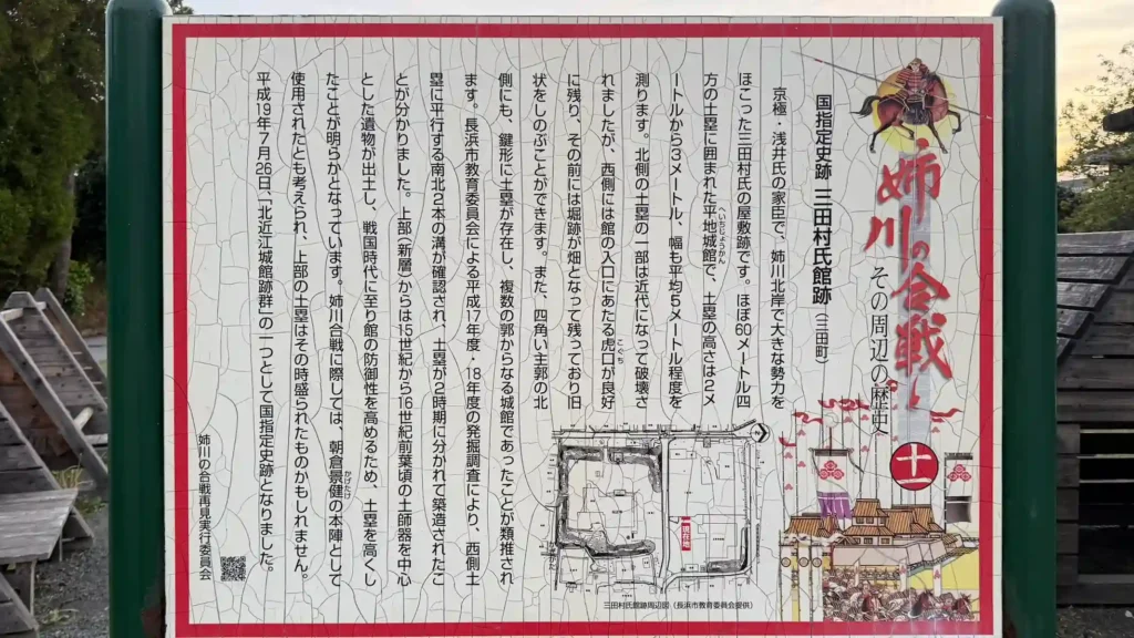
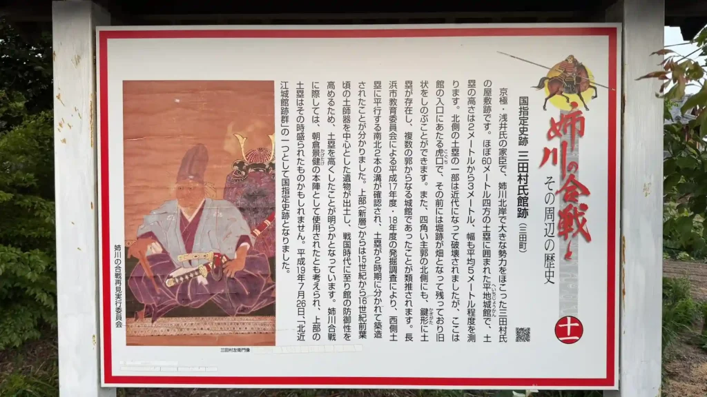
The Mitamura Residence Site is the remains of a medieval flatland fortified residence in Mita-cho on the north bank of the Anegawa River. It was the residence of the Mitamura clan, who served the Kyogoku clan and later the Azai clan, and during the Battle of Anegawa in 1570 it is known as the place where Asakura Kagetake, commander of the Asakura forces, placed his headquarters. Today, earthen ramparts and moat remains survive around the grounds of Denshoji Temple. The thick ramparts enclosing a roughly 60-meter-square central enclosure preserve the defensive space of a Sengoku-period local lord.
📜 Historic Site Data
| Construction Period | Late 15th to early 16th century |
|---|---|
| Structure / Features | A flatland fortified residence in which earthen ramparts enclose a roughly 60-meter-square central enclosure. The ramparts are about 2–3 meters high and about 5 meters wide; the entrance and moat remains also survive. |
| Repairs / Reconstruction | The earthen ramparts and other features were rebuilt in the first half of the 16th century. |
| Cultural Property Designation | National Historic Site: “Northern Omi Fortified Residence Sites: Shimosaka Residence Site and Mitamura Residence Site.” Added to the designation on July 26, 2007. |
| Notes | During the Battle of Anegawa, the site is known as the place where Asakura Kagetake’s forces placed their headquarters. |
👀 Highlights
- Ramparts surrounding the central enclosure: Earthen ramparts remain around the roughly 60-meter-square residence site, allowing visitors to read the defensive character of a Sengoku-period flatland residence on the ground.
- Entrance and moat remains: The entrance and surrounding moat remains show that this was not merely a residence, but a fortified home with military defenses.
- Walking the grounds of Denshoji Temple: The center of the residence site is now within Denshoji Temple, where visitors can walk around the temple grounds and see the rise of the ramparts.
📌 Trivia
- The power of the Mitamura clan: The Mitamura clan were local lords who served the Kyogoku and Azai clans and held considerable influence on the north bank of the Anegawa.
- Asakura Kagetake’s headquarters: The site is traditionally known as the headquarters of Asakura Kagetake’s forces, who came from Echizen to support Azai Nagamasa.
🗺 Address
Mita-cho, Nagahama City, Shiga Prefecture
🚶 Access
Travel west from Chihara Park (Signboard No. 7). Denshoji Temple is the landmark.
🚗 Parking
Parking space available near Denshoji Temple (please confirm in advance)
⏳ Suggested Visit Time
Quick visit: about 15 minutes / In-depth visit: about 40 minutes
💴 Admission
Free (temple grounds visit)
Panoramic Photo: Mitamura Residence Site (around Denshoji Temple)
Signboard No. 12: The Tombs of the Seventy Warriors
A quiet grave site lined with five-ring pagodas—a group of stone monuments honoring those who died at Anegawa
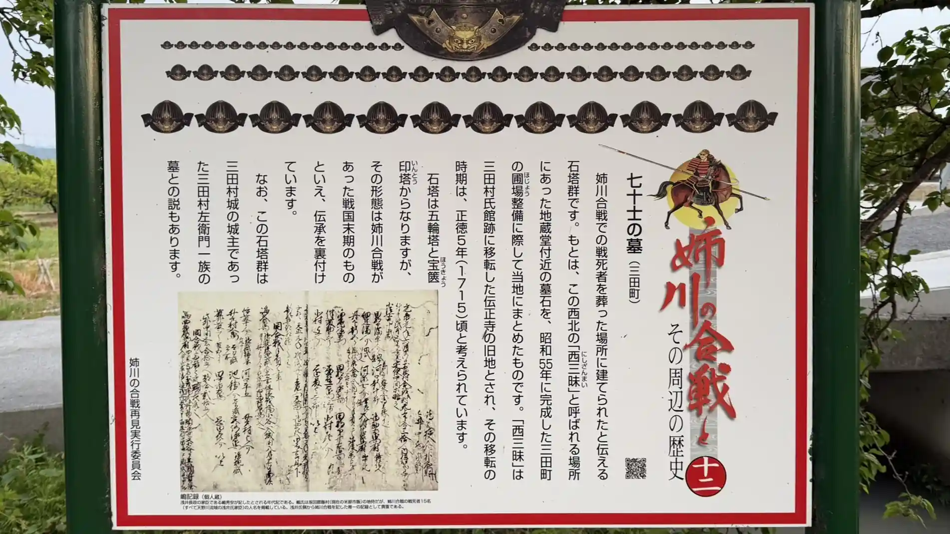
The Tombs of the Seventy Warriors are traditionally regarded as a group of stone monuments honoring those who died at the Battle of Anegawa. In a quiet corner of Mita-cho, stone towers including five-ring pagodas and hokyoin pagodas are gathered together, preserving the memory of prayers for nameless war dead. The monuments originally stood northwest of the current site in a place called Nishizanmai and were moved here during the farmland improvement project in Mita-cho.
📜 Historic Site Data
| Structure / Features | A group of stone monuments including five-ring pagodas and hokyoin pagodas, traditionally regarded as graves for those who died at the Battle of Anegawa. |
|---|---|
| Repairs / Relocation | Moved together to the present site during the Mita-cho farmland improvement project completed in 1980. |
| Cultural Property Designation | No information available |
| Notes | One theory identifies them as the graves of the family of Mitamura Saemon, lord of Mitamura Castle. The original site, Nishizanmai, is said to have been the former location of Denshoji Temple before it moved to the Mitamura Residence Site. |
👀 Highlights
- Stone monuments of the Seventy Warriors: Five-ring pagodas and hokyoin pagodas line the site, giving it a quiet gravity as a place of remembrance for lives lost at Anegawa.
- Proximity to the Mitamura Residence Site: Walking both sites together lets you experience a landscape where a medieval fortified residence and a place of memorial prayer overlap.
📌 Trivia
- The former site of Denshoji Temple: The original location, Nishizanmai, is said to have been the former site of Denshoji Temple before it was moved to the Mitamura Residence Site.
🗺 Address
655 Mita-cho, Nagahama City, Shiga Prefecture
🚶 Access
Within walking distance of the Mitamura Residence Site (Signboard No. 11).
🚗 Parking
No dedicated parking (please confirm in advance)
⏳ Suggested Visit Time
Quick visit: about 5 minutes / In-depth visit: about 15 minutes
💴 Admission
Free
Panoramic Photo: The Tombs of the Seventy Warriors
Signboard No. 13: Oyoriyama
The mountain where the Azai–Asakura forces temporarily encamped—viewing the stage of the pre-battle council from the museum
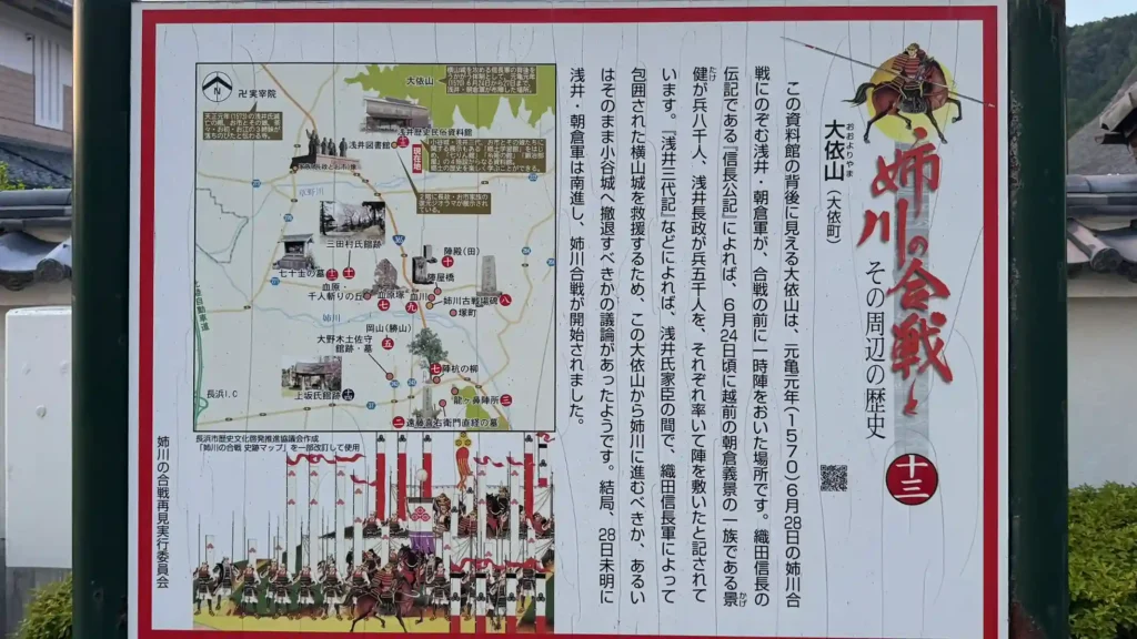
Oyoriyama, seen from near the Azai History and Folklore Museum, is known as the mountain where the allied forces of Azai Nagamasa and Asakura Kagetake temporarily encamped immediately before the Battle of Anegawa. In June 1570, as Oda Nobunaga attacked Yokoyama Castle, the Azai–Asakura forces took up a temporary position on this mountain. The on-site signboard introduces it as the place where they faced the decision of whether to advance toward Anegawa or withdraw to Odani Castle. At the foot of the mountain is a museum where you can learn about the history of the Azai clan; viewing the ridge after seeing the exhibits brings the tense pre-battle decision-making into sharper relief.
📜 Historic Site Data
| Structure / Features | A mountain near the Azai History and Folklore Museum where the Azai–Asakura forces temporarily encamped before the Battle of Anegawa. |
|---|---|
| Cultural Property Designation | No information available |
| Notes | The on-site signboard describes the mountain as the setting for a council over whether to advance toward Anegawa or retreat to Odani Castle. |
👀 Highlights
- Ridge of Oyoriyama: Looking toward the mountain from the museum area helps you imagine where the Azai–Asakura forces temporarily encamped.
- Azai History and Folklore Museum: A nearby museum where visitors can learn the background of the Azai clan before viewing the mountain.
📌 Trivia
- Advance from Oyoriyama to Anegawa: Before the Battle of Anegawa, the Azai–Asakura forces temporarily encamped at Oyoriyama and later advanced toward Nomura and Mita on the north bank of the Anegawa.
- Site of a military council: The mountain was the setting for the Azai–Asakura army’s debate over whether to move toward Anegawa or withdraw to Odani Castle.
🗺 Address
Near 528 Oyoricho, Nagahama City, Shiga Prefecture
🚶 Access
A few minutes by car from JR Kawake Station. The Azai History and Folklore Museum is the main landmark.
🚗 Parking
Use the parking lot at the Azai History and Folklore Museum (please confirm in advance)
⏳ Suggested Visit Time
Quick visit: about 15 minutes / In-depth visit: about 60 minutes, including the museum
💴 Admission
The Azai History and Folklore Museum requires a separate admission fee (please confirm). Viewing the mountain is free.
Panoramic Photo: Oyoriyama
Signboard No. 14: Kozaka Clan Residence Site
A medieval fortified residence site of the Kozaka clan, powerful retainers of the Kyogoku and Azai, preserved in Marunouchi
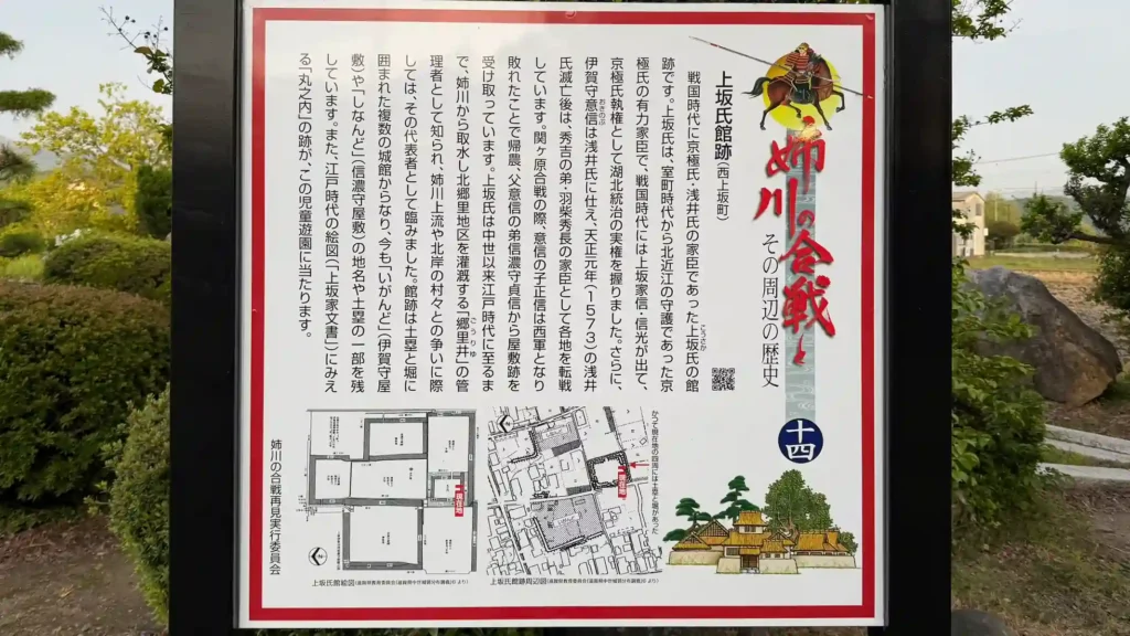
The “Kozaka Clan Residence Site” signboard, standing near the Kozaka Castle site, introduces the medieval powers on the south bank of the Anegawa. The Kozaka clan were influential retainers of the Kyogoku clan, the shugo governors of northern Omi from the Muromachi period, and later also served the Azai and Hashiba clans as local lords of Kohoku. The residence site is in Nishikozaka-cho, Nagahama City, where a castle-site marker stands in an area called Marunouchi. In the village landscape, visitors can still read traces of a medieval warrior residence equipped with a moat and earthen embankments.
📜 Historic Site Data
| Construction Period | Muromachi period |
|---|---|
| Builder | Kozaka clan |
| Structure / Features | A flatland residence site. A castle-site marker stands in the area called Marunouchi, and the site is known as a residence equipped with a moat and earthen embankments. |
| Current Remains | The castle-site marker and part of the earthen ramparts remain. |
| Notes | Around Marunouchi, the names of residence plots such as Iga-no-kami Residence, Shinano-no-kami Residence, and Mihara Residence have been preserved. |
👀 Highlights
- Marunouchi residence site: The core area of the Kozaka clan residence, where a castle-site marker preserves the memory of the medieval site.
- Traces of a local warrior family: The surrounding village landscape still reflects the structure of a residence with a moat and earthen embankments.
📌 Trivia
- Retainers across changing regimes: The Kozaka clan served the Kyogoku, Azai, and Hashiba clans, showing how local powers in northern Omi adapted through changing political eras.
- Residence names in the landscape: Place-names such as Iga-no-kami Residence and Shinano-no-kami Residence preserve the memory of the area’s former warrior households.
🗺 Address
Nishikozaka-cho, Nagahama City, Shiga Prefecture
🚶 Access
Located near the Kozaka Castle site in the Nishikozaka-cho settlement.
🚗 Parking
No dedicated parking (please confirm in advance)
⏳ Suggested Visit Time
Quick visit: about 5 minutes / In-depth visit: about 15 minutes
💴 Admission
Free
Panoramic Photo: Kozaka Clan Residence Site
Frequently Asked Questions
Yes. Outdoor historic sites such as the Anegawa Battlefield remains, Jinkui no Yanagi, the grave of Endo Naotsune, the Mitamura Residence Site, and the Tombs of the Seventy Warriors can all be visited free of charge. The Azai History and Folklore Museum requires a separate admission fee. The exhibition room at Ishida Hall, located at the Ishida Mitsunari Residence Site, can be visited free of charge, but it is not always open. Please confirm opening days before visiting.
If you visit all the spots on foot, plan on about 3 to 4 hours, including travel time between locations. By bicycle or car, you can cover the major spots in roughly 2 hours.
The Battle of Anegawa was fought on June 28, 1570, between the allied forces of Oda Nobunaga and Tokugawa Ieyasu and the allied forces of Azai Nagamasa and Asakura Kagetake along the Anegawa River. The Oda–Tokugawa alliance ultimately won.
It is the remains of a medieval flatland fortified residence in Mita-cho on the north bank of the Anegawa. It is part of the nationally designated historic site “Northern Omi Fortified Residence Sites.” Earthen ramparts enclosing a roughly 60-meter-square central enclosure remain at a height of about 2 to 3 meters, and traces of the entrance and moat can also be seen.
By car, the battlefield area is about 15 to 20 minutes from JR Nagahama Station. If using public transportation only, you can take a Kokoku Bus from Nagahama Station to the nearest bus stop and continue on foot. Because the historic sites are spread across a wide area, traveling by bicycle or car is the most efficient option. The parking lot at the Kitagori Community Development Center is commonly used as a starting point for the route.
Yes. In the area covered by Signboards No. 6 and No. 15, you will find Ishida Hall, located at the site of Ishida Jibu-shosuke Mitsunari’s residence. Ishida Mitsunari was born in 1560 in Ishida Village, Sakata District, Omi Province, present-day Ishida-cho, Nagahama City, Shiga Prefecture. Outside the hall are a birthplace monument and a statue of Mitsunari, and inside is an exhibition room related to him.
Open the detailed accordion for each spot to display its panoramic photo. On a computer, drag with your mouse; on a smartphone or tablet, swipe with your finger to move the viewpoint left and right. Use them to preview the atmosphere of each site before visiting.
* The historic site information on this page is based on on-site information boards, public materials from the Nagahama City Board of Education, and materials related to nationally designated historic sites. Please check the latest information before visiting.
* Please confirm the latest access conditions, opening days, parking availability, and admission information with each facility’s official sources before visiting.
* Please confirm the admission fee and opening hours of the Azai History and Folklore Museum on the official Nagahama City website.
* For an overview of the Anegawa Battlefield, access information, and a guide to the main highlights, see Anegawa Battlefield Highlights and Walking Guide.
comment