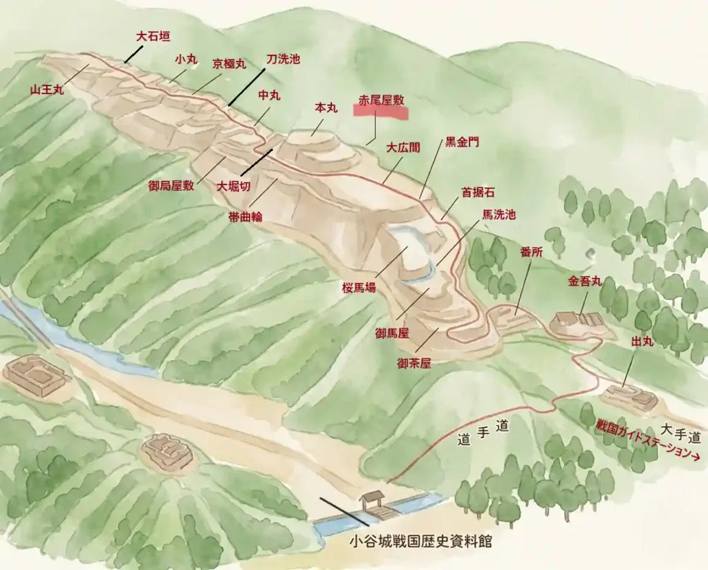
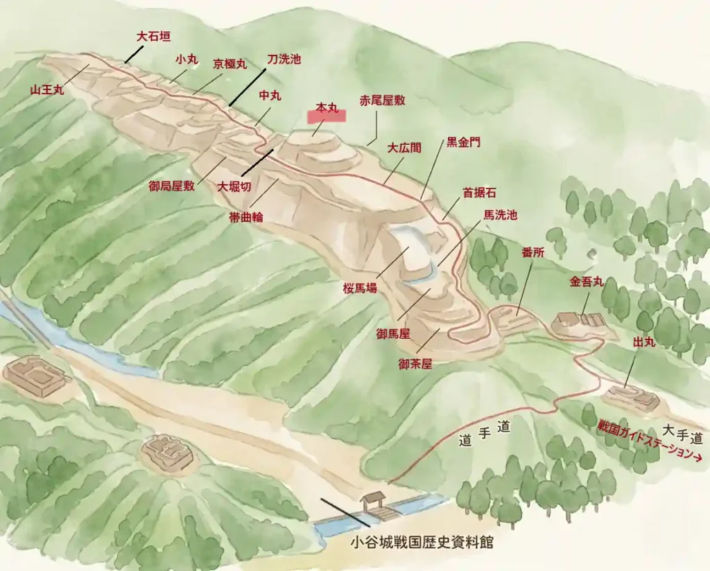
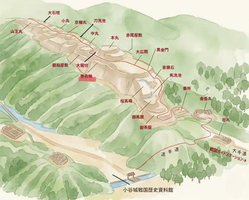
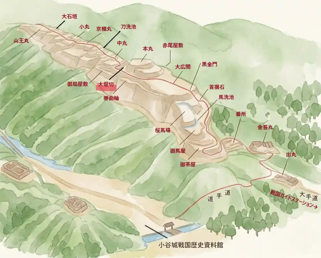
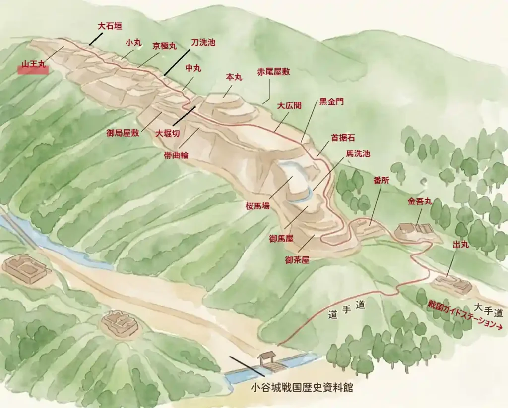
Honmaru, Sannomaru, and the Great Stone Walls | 14 Main-Bailey Sites at Odani Castle Ruins
This guide follows the main-bailey route through Odani Castle Ruins in walking order, from the entrance to the core of the castle all the way to Sannomaru. It covers 14 sites with photos: Kubisue-ishi, Kurogane Gate Site, Ohiroma, Akao Residence, Honmaru, Obikuruwa, Otsubone Residence, the Large Dry Moat, Nakamaru, Katanaraike Pond, Kyogokumaru, Komaru, the Great Stone Walls, and Sannomaru. For the lower and forward-defense area from the museum to Sakurababa, see this area guide. For basic access information, see the Odani Castle Ruins main guide.

Odani Castle Spot Guide | Main Bailey Route
Kubisue-ishi Stone
A massive stone traditionally linked to the 1533 display of Imai Hidenobu’s severed head by Azai Sukemasa.
Kubisue-ishi is a large stone that remains just before the Kurogane Gate. According to tradition, in January 1533, Azai Sukemasa displayed here the head of Imai Hidenobu, who had allegedly communicated with the enemy. The episode predates Azai Nagamasa and reminds visitors that Odani Castle was built on a strict military order from its earliest days.
- The stone itself: Its rough, natural presence makes visitors stop even before reading the signboard.
- Position before Kurogane Gate: Its location at the main-bailey entrance suggests that punishment and authority were part of the castle’s spatial order.
- Seasonal tip: In the leafless season, the surrounding landforms and the relationship with Kurogane Gate are easier to read.

Quick visit: about 3 min / Slow visit: about 10 min
📷 View Kubisue-ishi in 360° panoramic photos
🗺 Address: Odani Castle Ruins, near Kubisue-ishi, Kohoku-cho Ibe, Nagahama, Shiga
🚶 Access: About 2 minutes on foot from Sakurababa via Uma-arai-ba.
| Date | Unknown |
|---|---|
| Features | A large stone before Kurogane Gate, remembered in local tradition as a symbol of punishment. |
| Current state | The large stone, stone marker, and information board remain. |
| Status | Part of the National Historic Site “Odani Castle Ruins.” |
- The Kubisue-ishi story belongs to the age of the first Azai lord, Sukemasa, not to Nagamasa’s generation.
- A side path to the right leads toward the Akao Residence, one of the most poignant places connected to the castle’s fall.
Kurogane Gate Site
Stone steps and walls about 3.5 meters high mark the formal front entrance to Odani Castle’s main bailey.
This was the front gate into the main-bailey area of Odani Castle. Placed at the end of the climbing route, it led directly into Ohiroma. Stone steps and stone walls remain, with walls about 3.5 meters high on both sides. For a mountain castle, the entrance still feels impressively formal and powerful.
- Stone steps and gate site: After the mountain path, the steps clearly signal that you are entering the castle core.
- Stone walls on both sides: The high walls communicate both defensive strength and prestige.
- Seasonal tip: In the leafless season, the outline of the steps and walls becomes easier to see.

Quick visit: about 3 min / Slow visit: about 10 min
📷 View Kurogane Gate Site in 360° panoramic photos
🗺 Address: Odani Castle Ruins, near Kurogane Gate Site, Kohoku-cho Ibe, Nagahama, Shiga
🚶 Access: 1 minute on foot from Kubisue-ishi.
| Date | Unknown |
|---|---|
| Features | A gate site east of Ohiroma, with stone steps leading to the Ohiroma entrance and walls about 3.5 meters high on both sides. |
| Maintenance | Included in historic-site improvements around 1970. No reconstructed gate building exists. |
| Current state | Stone walls, stone steps, and gate landform remain. |
| Status | Part of the National Historic Site “Odani Castle Ruins.” |
- This was not a side gate: it was the entrance into the political and military core of the castle.
- Some guide materials call it Kuroganegomon, while technical materials often use Kurogane Gate Site.
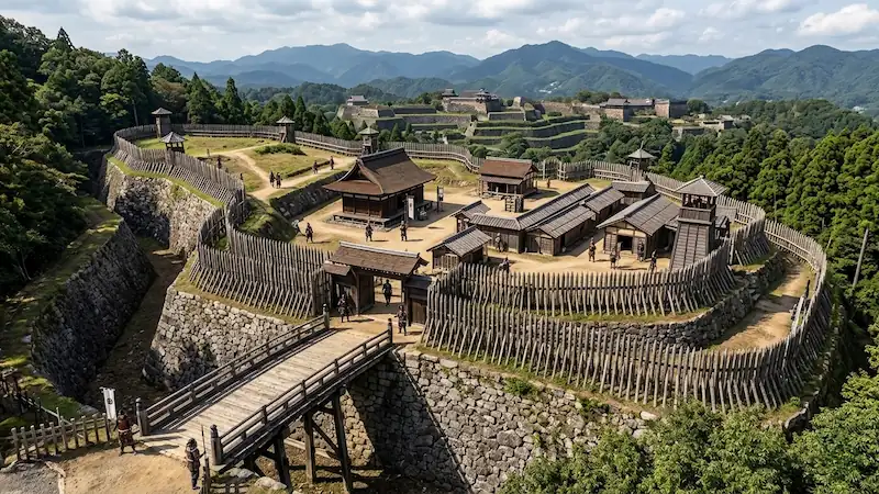
Ohiroma | Senjojiki
About 35 meters east-west and 85 meters north-south: the political heart where Azai Nagamasa likely held government and war councils.
Ohiroma is the broad central bailey of Odani Castle’s main area and is also known as Senjojiki. It is thought to have been used for administration, military councils, ceremonies, and the reception of retainers. Excavations have confirmed many building remains and artifacts.
- Scale of Senjojiki: The vast flat area high on the mountain makes the castle’s political function easy to feel.
- Stone-built remains: Well remains, stone-lined drains, storehouse traces, and paving reveal the infrastructure that supported everyday life and administration.
- Seasonal tip: From spring to early summer, the bailey surface is bright and the line of stone walls is easier to grasp.

Quick visit: about 5 min / Slow visit: about 10 min
📷 View Ohiroma / Senjojiki in 360° panoramic photos
🗺 Address: Odani Castle Ruins, near Ohiroma, Kohoku-cho Ibe, Nagahama, Shiga
🚶 Access: About 2 minutes from Kurogane Gate Site.
| Date | Unknown |
|---|---|
| Features | Also called Senjojiki. A flat area about 35 m east-west, 85 m north-south, and around 3,000 m², with building remains, wells, drains, storehouse traces, paving, and stone alignments. |
| Maintenance | Improved in 1971 and planted with grass in 1972. |
| Current state | Large bailey surface, stone walls, and visible remains. |
| Status | Part of the National Historic Site “Odani Castle Ruins.” |
- Excavation shows that this was not simply an empty open space; many buildings and artifacts were found here.
- Foundation stones are arranged at intervals of about 191 cm, suggesting a planned building layout.
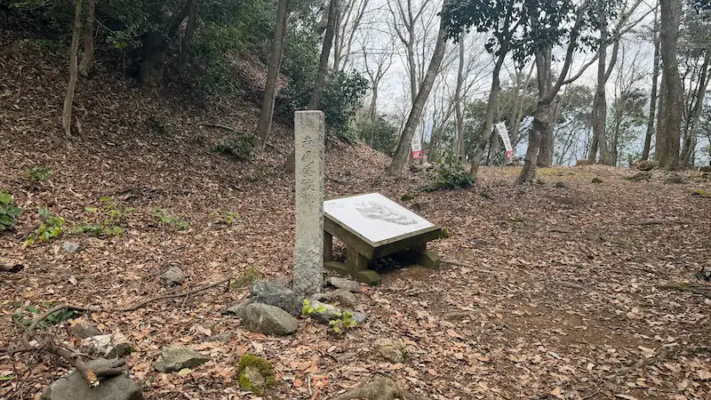
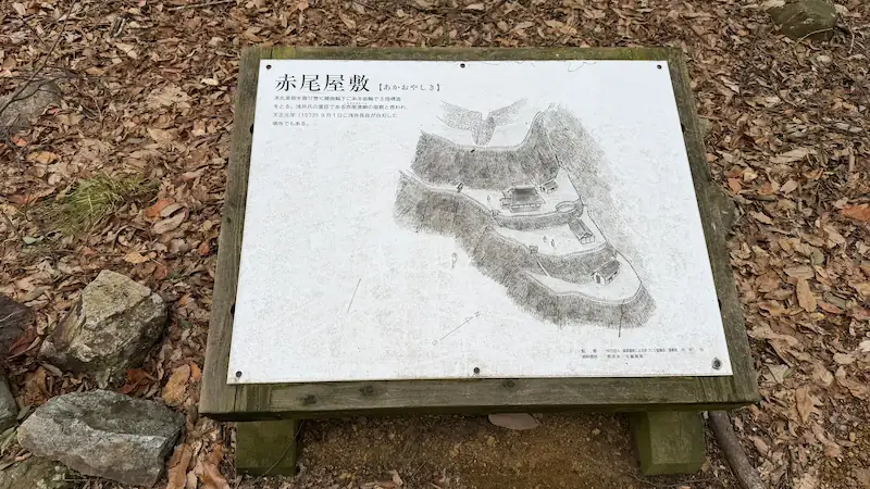
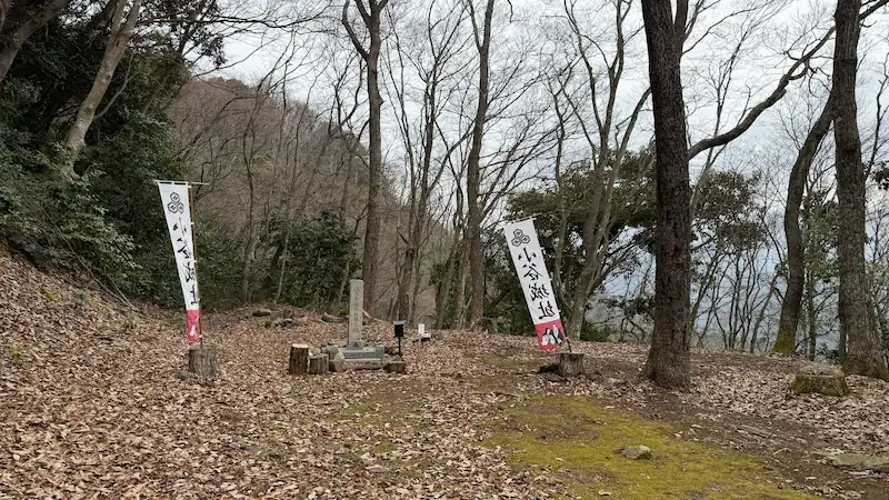
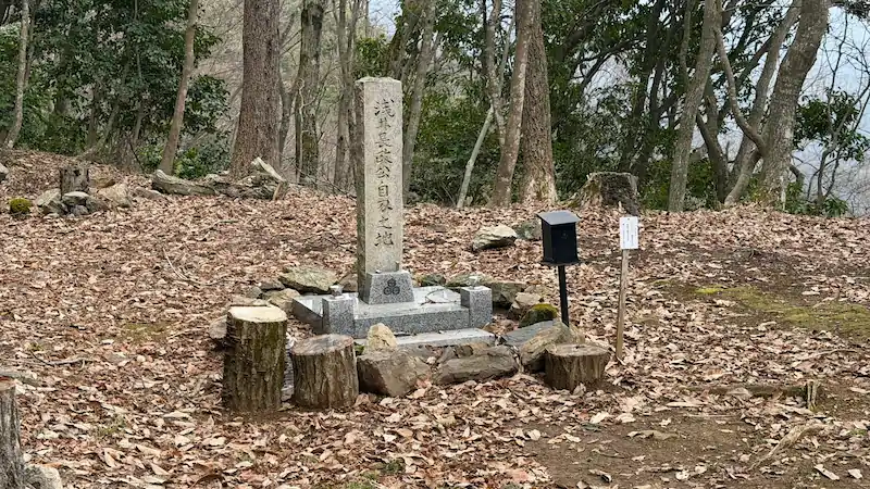
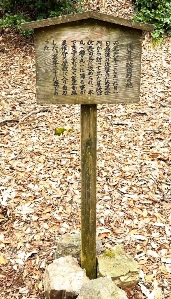
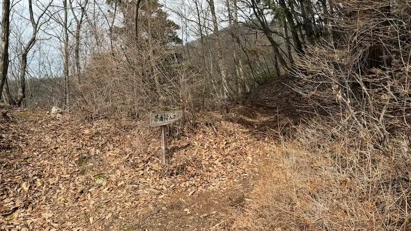
Akao Residence Site
Three terraced baileys below and east of the Honmaru, traditionally known as the place where Azai Nagamasa took his own life.
The Akao Residence Site is a three-tiered bailey below and east of the Honmaru. It is traditionally associated with the residence of the Akao family, senior retainers of the Azai. In the final moments of Odani Castle’s fall, Azai Nagamasa is said to have met his end in this area.
- Three-tiered bailey: Although it was a residence area, its tiered structure also shows a defensive awareness.
- Atmosphere of the final moment: A stone monument and information board mark it as a place tied to the castle’s collapse.
- Seasonal tip: From late autumn into winter, the terraces and drop toward the valley become easier to see.
Quick visit: about 5 min / Slow visit: about 15 min
📷 View Akao Residence and Azai Nagamasa memorial site in 360° panoramic photos
🗺 Address: Odani Castle Ruins, near Akao Residence Site, Kohoku-cho Ibe, Nagahama, Shiga
🚶 Access: About 5 minutes from Ohiroma, roughly 0.23 km. Take the side path to the right before Kurogane Gate.
| Date | Unknown; established by the early Sengoku period |
|---|---|
| Features | A three-tiered bailey below and east of the Honmaru, about 180 m along the side path from before Kurogane Gate. |
| Maintenance | Improved during environmental works from 1970 to 1975. |
| Current state | Bailey landform, stone marker, and information board remain. |
| Status | Part of the National Historic Site “Odani Castle Ruins.” |
- This was not far from the Honmaru; it was positioned very close to the castle core as a senior retainer’s residence.
- Preservation plans describe it as about 180 m along the right-hand path before Kurogane Gate.
Honmaru
The core bailey associated with Azai Nagamasa, protected by stone walls, earthworks, steep slopes, and the Large Dry Moat.
The Honmaru was the political and military center of Odani Castle. It sits above and northeast of Ohiroma, protected by steep slopes, earthworks, stone walls, and the Large Dry Moat. In Edo-period castle drawings, the area is noted with phrases connected to a tower and bell bailey, and it is often discussed as a place closely associated with Azai Nagamasa.
- Main-bailey location: Raised above Ohiroma, it expresses the status of the lord’s core space through the landform itself.
- Stone walls and earthworks: The combination of stone and earth defenses around the main bailey is a key point.
- Seasonal tip: In winter, fallen leaves reveal the relationship between the Honmaru, Large Dry Moat, and neighboring baileys.

Quick visit: about 5 min / Slow visit: about 10 min
📷 View Honmaru in 360° panoramic photos
🗺 Address: Odani Castle Ruins, near Honmaru, Kohoku-cho Ibe, Nagahama, Shiga
🚶 Access: About 7 minutes from Akao Residence, roughly 0.25 km.
| Date | Unknown |
|---|---|
| Features | An irregular main bailey above the northeast side of Ohiroma, about 25 m east-west and 40 m north-south, divided into two levels, with stone walls and earthworks. |
| Maintenance | Landscape improvements were carried out around the Honmaru in 1973. |
| Current state | Bailey landform, stone walls, earthworks, and information board remain. |
| Status | Part of the National Historic Site “Odani Castle Ruins.” |
- The Honmaru’s strength lies not in size alone but in the defensive system surrounding it.
- The name Kanemaru in old drawings may point to an older or more specific function of the space.
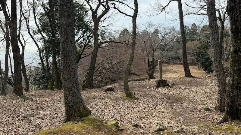
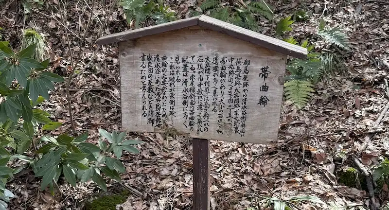
Obikuruwa
A long, narrow belt bailey extending from Oumaya toward the Shimizudani side, protecting the Honmaru from the slope.
Obikuruwa is a narrow bailey that runs from Oumaya under the Honmaru toward the Shimizudani side. Odani Castle’s defenses were not limited to the ridge line; they also layered protection along the slopes. This area makes that design especially clear.
- Long belt-like structure: It follows the slope rather than the ridge, revealing the castle’s defensive thinking.
- Defense below the Honmaru: The landform itself lets you feel how the Honmaru and Ohiroma were protected from the side.
- Seasonal tip: In winter, the slope becomes easier to read and the length of the bailey is more visible.
Quick visit: about 5 min / Slow visit: about 10 min
📷 View Obikuruwa in 360° panoramic photos
🗺 Address: Odani Castle Ruins, near Obikuruwa, Kohoku-cho Ibe, Nagahama, Shiga
🚶 Access: About 3 minutes from Honmaru, roughly 0.08 km.
| Features | A belt-shaped bailey 3 to 5 m wide, running from Oumaya toward the Shimizudani slope and behind the Honmaru toward Nakamaru. A stone wall about 5 m high was built near Ohiroma. |
|---|---|
| Current state | The belt-like bailey and traces of stonework remain. |
| Status | Part of the National Historic Site “Odani Castle Ruins.” |
- Odani Castle placed many defenses not only on the main ridge but also on the Shimizudani-side slopes.
- It is easy to miss if you walk directly from Oumaya toward the Honmaru without looking for it.
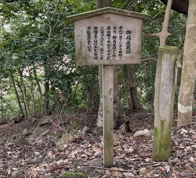
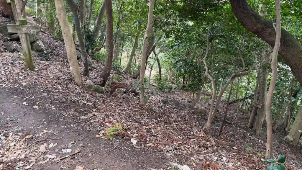
Otsubone Residence Site
A small residence site on the Shimizudani side, traditionally connected with Oichi and the women of the castle.
The Otsubone Residence Site is a small residence area west of Nakamaru, facing Shimizudani. Local tradition sometimes links it to Oichi and the women serving within the castle. Unlike purely military spaces, it invites visitors to imagine the castle as a lived-in place.
- Location below the Honmaru: Slightly off the line between Honmaru and Nakamaru, it suggests an inner residential zone.
- Connection to Obikuruwa: Seen together with the belt bailey from Oumaya, it helps explain movement along the west side of the main bailey.
- Seasonal tip: In autumn, fallen leaves reveal the shape and scale of the residence site more clearly.
Quick visit: about 3 min / Slow visit: about 10 min
📷 View Otsubone Residence Site in 360° panoramic photos
🗺 Address: Odani Castle Ruins, near Otsubone Residence Site, Kohoku-cho Ibe, Nagahama, Shiga
🚶 Access: About 5 minutes from Obikuruwa, roughly 0.12 km.
| Features | A small residence site on the Shimizudani side of Nakamaru, about 35 m north-south and 10 m east-west, connected to Obikuruwa from Oumaya. |
|---|---|
| Current state | Bailey landform, scattered stone material, and information board remain. |
| Status | Part of the National Historic Site “Odani Castle Ruins.” |
| Notes | Local tradition connects it with Oichi and the women of the castle. |
- Although part of a mountain castle, this site may have had the character of a residential or living space rather than a purely military facility.
- It is slightly off the main route from Honmaru to Nakamaru, so it is easy to miss unless you look for it.
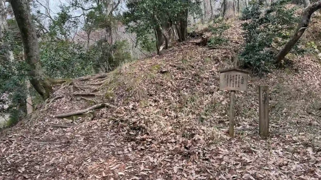
Large Dry Moat Site
A major dry moat cutting the ridge north of the Honmaru — the boundary where Hideyoshi’s attack split the castle.
The Large Dry Moat cuts deeply across the ridge north of the Honmaru. Standing here, you can clearly feel how Odani Castle was divided between its front core and the northern bailey group. During the 1573 assault, Hashiba Hideyoshi is said to have pressed the attack from the Kyogokumaru side, breaking the connection between the Honmaru and the northern defenses. This moat forms exactly that boundary.
- Scale of the ridge cut: The land drops sharply just north of the Honmaru, making its defensive purpose immediately clear.
- Division between Honmaru and Kyogokumaru: It is essential for understanding the relationship between Nagamasa’s Honmaru and the northern bailey group.
- Seasonal tip: In winter, the depth of the moat and both slopes are easier to read.
Quick visit: about 5 min / Slow visit: about 10 min
📷 View the Large Dry Moat in 360° panoramic photos
🗺 Address: Odani Castle Ruins, near the Large Dry Moat, Kohoku-cho Ibe, Nagahama, Shiga
🚶 Access: About 3 minutes from Otsubone Residence, roughly 0.05 km.
| Features | A large dry moat north of the Honmaru, dividing the southern bailey group from the northern group leading to Nakamaru, Kyogokumaru, Komaru, and Sannomaru. |
|---|---|
| Current state | The dry-moat landform remains clearly visible. |
| Status | Part of the National Historic Site “Odani Castle Ruins.” |
- Although it lies “behind” the Honmaru, the Large Dry Moat functioned as a defensive line that divided the castle core.
- The route from Ohiroma to this moat is almost level, making it easy to understand the structure of the main-bailey area while walking.
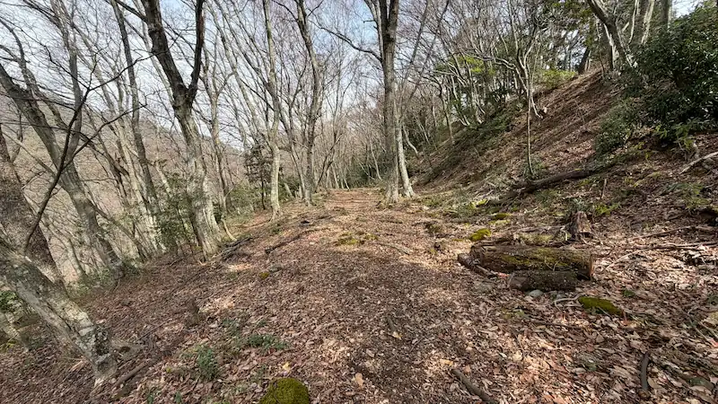
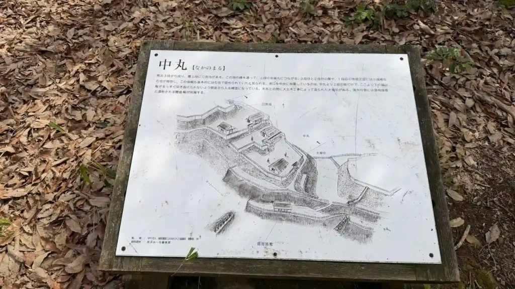
Nakamaru
Three terraced baileys north of the Large Dry Moat, with flanking-fire design and stonework behind the main bailey.
Nakamaru is a set of three terraced baileys beyond the deep Large Dry Moat north of the Honmaru. Though it lies behind the main bailey, it was also designed to respond to intrusion from the Honmaru side, showing that Odani Castle did not assume attack from only one direction.
- Three-tiered structure: Each level changes the line of sight and movement, giving the northern defenses a dense, layered feel.
- Flanking fire: The middle level includes a design that would allow defenders to attack from the side.
- Seasonal tip: From autumn through winter, stonework and cut slopes are easier to distinguish.

Quick visit: about 3 min / Slow visit: about 10 min
📷 View Nakamaru in 360° panoramic photos
🗺 Address: Odani Castle Ruins, near Nakamaru, Kohoku-cho Ibe, Nagahama, Shiga
🚶 Access: About 5 minutes from the Large Dry Moat, roughly 0.10 km.
| Features | Three terraced baileys north of the Large Dry Moat. The middle level includes a flanking-fire arrangement, and stonework can be seen on the slope. |
|---|---|
| Maintenance | Landscape improvements were carried out in 1974. |
| Current state | Three-tiered bailey landform, stonework, and information board remain. |
| Status | Part of the National Historic Site “Odani Castle Ruins.” |
- Even behind the Honmaru, Nakamaru had independent entrance and defensive features.
- Beyond Nakamaru, the route continues to Katanaraike Pond, Kyogokumaru, Komaru, and Sannomaru, revealing the depth of Odani’s rear defenses.
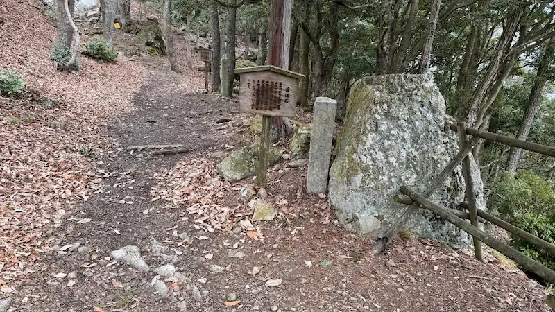
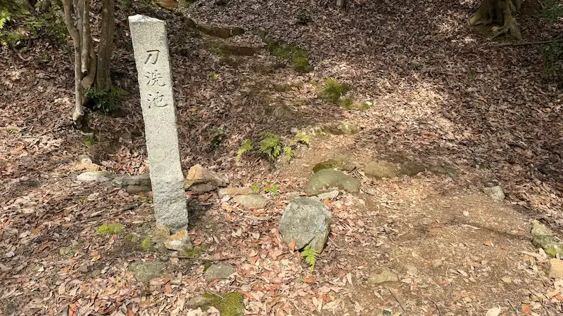
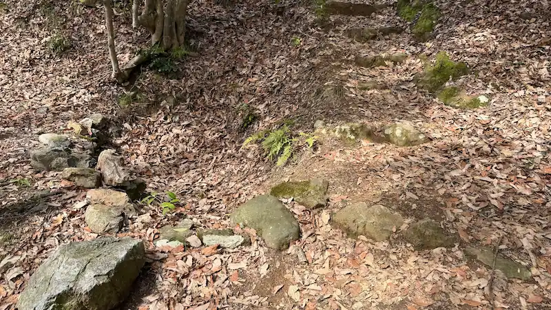
Katanaraike Pond Site
A rock-cut water reservoir inside the castle, connected with the “water source” mentioned in the Shinchō Kōki.
Katanaraike Pond is a small pond site on the left as you walk from Nakamaru toward Kyogokumaru. Preservation plans identify it as a castle water source, or mizu-no-te. During a siege, securing water was a matter of survival, and the Shinchō Kōki includes a passage about pursuing the defenders as far as the water source.
- Tub-like pond structure: It is not just a natural hollow; the rock was worked to collect water.
- Stonework traces: Stones along the side show its character as a water facility inside the castle.
- Seasonal tip: After rain or in damp periods, the shape of the pond is easier to understand.

Quick visit: about 3 min / Slow visit: about 10 min
📷 View Katanaraike Pond in 360° panoramic photos
🗺 Address: Odani Castle Ruins, near Katanaraike Pond, Kohoku-cho Ibe, Nagahama, Shiga
🚶 Access: On the left while walking from Nakamaru toward Kyogokumaru.
| Features | A water-reservoir site to the left of the route from Nakamaru to Kyogokumaru. Rock was cut into a tub-like form, with stonework about 50 cm high to receive seepage water. |
|---|---|
| Maintenance | Improved with Nakamaru, Kyogokumaru, and Komaru in 1974. |
| Current state | Pond remains and part of the stonework remain. |
| Status | Part of the National Historic Site “Odani Castle Ruins.” |
- Despite the dramatic name “sword-washing pond,” it is now generally understood as a water source that supported daily life and siege defense.
- Preservation plans regard it as a mizu-no-te, making it important for understanding water management in the castle.
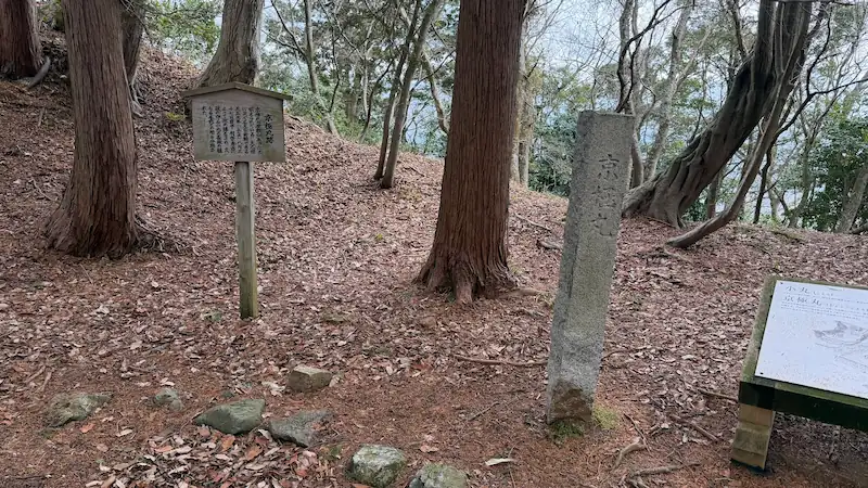
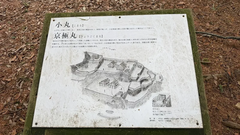
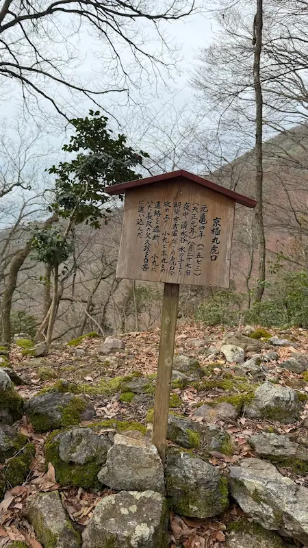
Kyogokumaru
A broad bailey group named for the Kyogoku family, with earthworks, stonework, and a fortified entrance on the Shimizudani side.
Kyogokumaru is a large bailey group north of Nakamaru. Its name is said to come from the Kyogoku family, whom the Azai sheltered here. The area includes long earthworks on the east side, broad baileys on the Shimizudani side, and an entrance reinforced with stonework. It was also a crucial point in Hideyoshi’s attack during the fall of Odani Castle.
- Large bailey group: After Ohiroma, this is one of the most spacious parts of the castle core.
- Eastern earthworks: The long remaining earthwork shows the defensive strength of the area.
- Seasonal tip: In winter, the outline of the earthworks and entrance is easier to read.

Quick visit: about 5 min / Slow visit: about 10 min
📷 View Kyogokumaru and its entrance in 360° panoramic photos
🗺 Address: Odani Castle Ruins, near Kyogokumaru, Kohoku-cho Ibe, Nagahama, Shiga
🚶 Access: About 8 minutes from Katanaraike Pond, roughly 0.20 km.
| Features | A broad bailey group second in scale to Ohiroma, with earthworks about 3 m high on the east, broad baileys on the Shimizudani side, and a stone-reinforced entrance with three-tier cut slopes in the southwest. |
|---|---|
| Maintenance | Improved with Nakamaru and Komaru in the 1974 program. |
| Current state | Baileys, earthworks, entrance, traces of stonework, and information boards remain. |
| Status | Part of the National Historic Site “Odani Castle Ruins.” |
| Notes | The name is said to derive from hosting Kyogoku Takakiyo and his family. |
- Its name preserves the relationship between the Azai and Kyogoku families.
- The stone-reinforced entrance on the southwest Shimizudani slope shows that this area became a focal point of attack and defense.
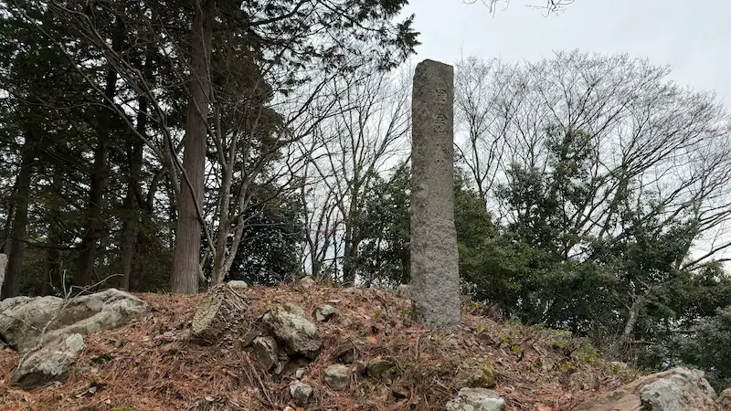
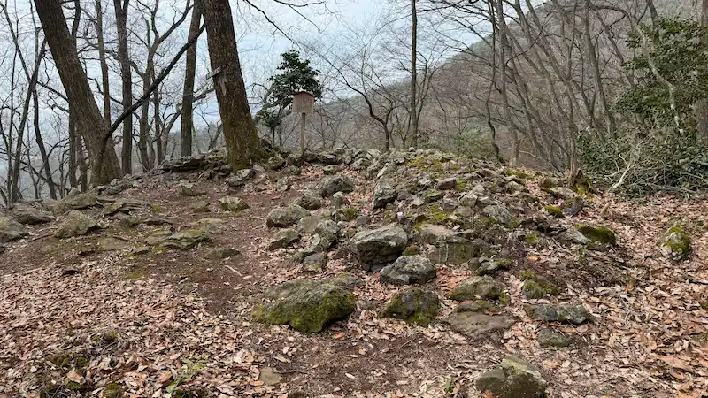
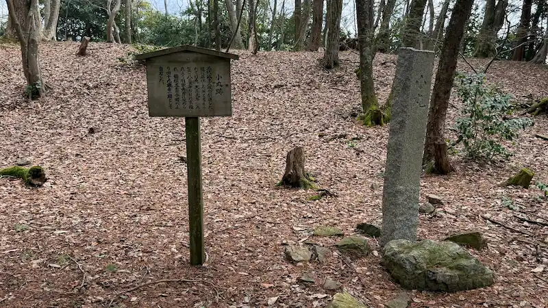
Komaru
The retirement residence and death site traditionally associated with Azai Hisamasa, showing how father and son defended the castle together.
Komaru is a bailey above Kyogokumaru and is traditionally regarded as the retirement residence of Azai Hisamasa. While Azai Nagamasa defended the Honmaru, his father Hisamasa supported the northern side of the castle from Komaru. Hideyoshi’s attack eventually reached this area, and Hisamasa is said to have taken his own life here before Nagamasa.
- Position above Kyogokumaru: Its slightly higher placement shows how it supported the castle from the rear.
- Father and son defensive layout: Thinking of Nagamasa in the Honmaru and Hisamasa in Komaru reveals the logic of Odani’s defense.
- Seasonal tip: From late autumn into winter, the height difference between nearby baileys is easier to follow.

Quick visit: about 5 min / Slow visit: about 10 min
📷 View Komaru in 360° panoramic photos
🗺 Address: Odani Castle Ruins, near Komaru, Kohoku-cho Ibe, Nagahama, Shiga
🚶 Access: About 3 minutes from Kyogokumaru, roughly 0.08 km.
| Features | A bailey above Kyogokumaru, about 25 m north-south and 30 m east-west, generally described as three terraced levels. |
|---|---|
| Maintenance | Improved together with Nakamaru and Kyogokumaru in 1974. |
| Current state | Bailey landform, stone marker, and information board remain. |
| Status | Part of the National Historic Site “Odani Castle Ruins.” |
| Notes | Traditionally known as Azai Hisamasa’s retirement residence and death site. |
- Although not especially large, Komaru is central to the final history of Odani Castle.
- Some preservation materials differ on the number of levels, describing it either as three tiers or as an upper and lower two-tier structure.
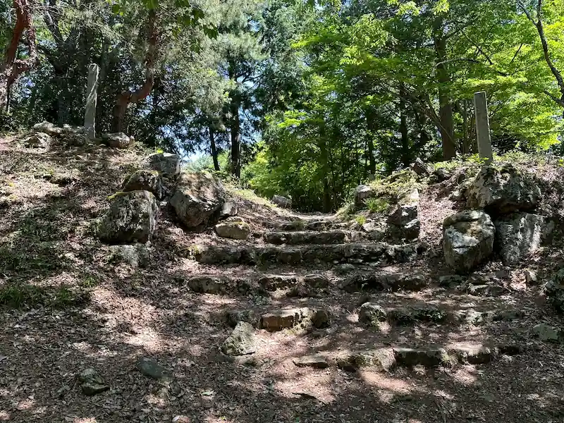
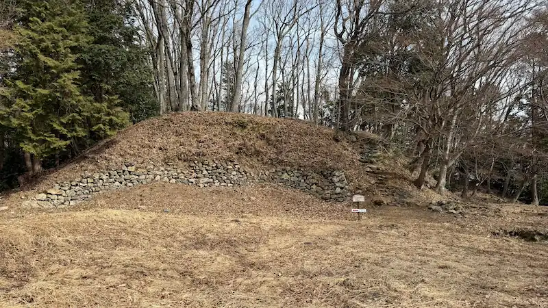
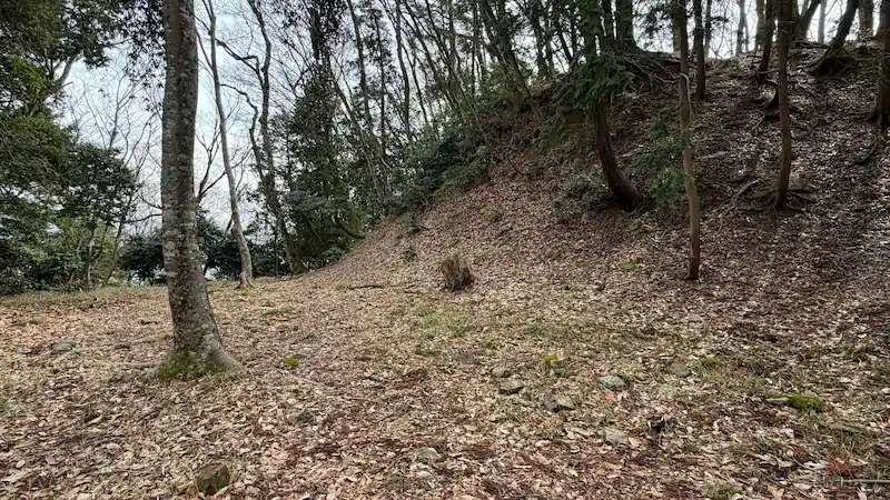
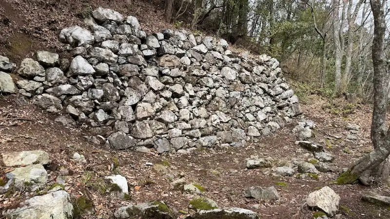
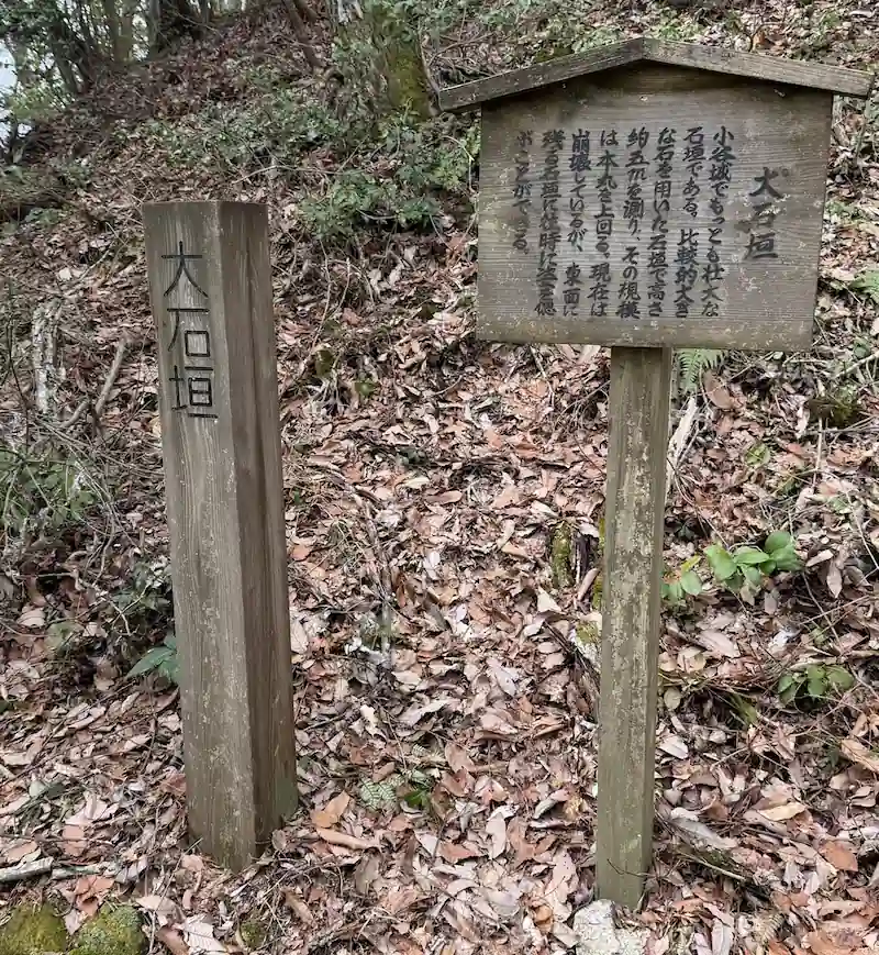
Great Stone Walls
Massive stone walls around Sannomaru, an imposing survival that reveals Odani Castle’s technical sophistication.
The Great Stone Walls are the large-stone walls seen around Sannomaru. When viewed together with Sannomaru, they make it easier to understand the defensive strength of this far northern part of the castle.
- Massive stonework: Few mountain-castle remains display stone so powerfully, and the walls show Odani’s high level of construction skill.
- Connection with Sannomaru: Seen as part of the final defensive bailey, the purpose of the stone walls becomes clearer.
- Seasonal tip: Fresh greenery and autumn leaves make the wall line stand out beautifully in photos.

Quick visit: about 5 min / Slow visit: about 15 min
📷 View the Great Stone Walls in 360° panoramic photos
🗺 Address: Odani Castle Ruins, near the Great Stone Walls, Kohoku-cho Ibe, Nagahama, Shiga
🚶 Access: On the right as you walk from Komaru toward Sannomaru.
| Features | Large-stone walls belonging to the Sannomaru stonework group. Sannomaru consists of four north-south tiers, and stone walls remain on the east, south, and north sides of the central bailey. |
|---|---|
| Current state | Stone walls and related bailey landforms remain. |
| Status | Part of the National Historic Site “Odani Castle Ruins.” |
- The Great Stone Walls are one of the clearest places to sense the castle’s construction technology.
- They are best understood together with Sannomaru, rather than as an isolated stone-wall fragment.
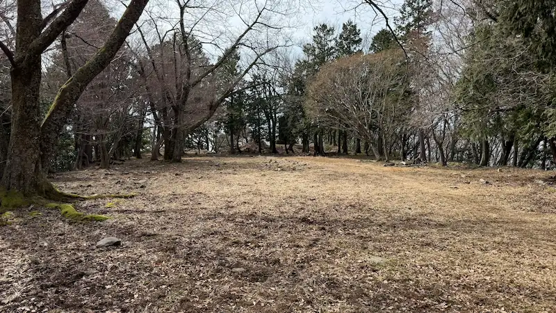
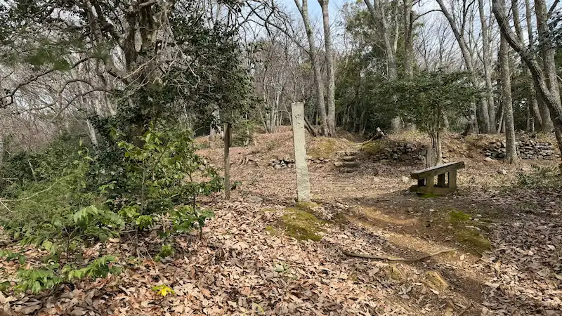
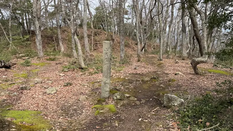
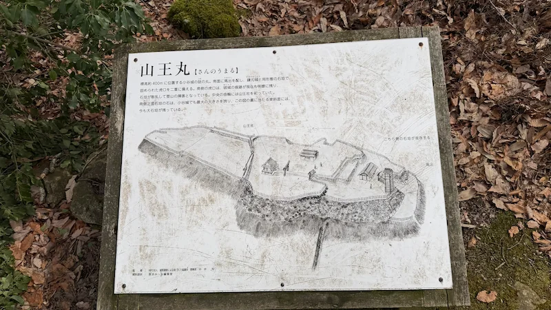
Sannomaru
The final bailey of Odani Castle, dedicated to Sannō Gongen, with four north-south tiers and massive stone walls.
Sannomaru was the final defensive bailey of Odani Castle. Its name comes from the enshrinement of Sannō Gongen, and it sits beyond the main bailey group, supporting the castle’s last line of defense. It consists of four north-south tiers and preserves stone walls built with large stones. Odani Castle is often discussed through the Honmaru and Akao Residence, but anyone who wants to understand its defensive power should continue as far as Sannomaru.
- Massive stone walls: They have a different impact from the main-bailey remains and are among the most memorable sights at Odani.
- Four-tiered bailey structure: The deeper you walk, the more clearly you feel the layered defenses of a final bailey.
- Seasonal tip: In fresh green or autumn foliage, the stone walls become especially expressive.
Quick visit: about 5 min / Slow visit: about 10 min
📷 View Sannomaru in 360° panoramic photos
🗺 Address: Odani Castle Ruins, near Sannomaru, Kohoku-cho Ibe, Nagahama, Shiga
🚶 Access: About 3 minutes from the Great Stone Walls, roughly 0.04 km.
| Features | The final bailey of Odani Castle, about 35 m east-west and 70 m north-south, made up of four north-south tiers. Stone walls remain on the east, south, and north sides of the central bailey. |
|---|---|
| Maintenance | Included in 1975 improvement works. |
| Current state | Bailey landform, stone walls, entrance features, and information board remain. |
| Status | Part of the National Historic Site “Odani Castle Ruins.” |
| Notes | The name comes from the former enshrinement of Sannō Gongen. |
- Sannomaru lies beyond the Honmaru and served as a high, final defensive space in the late-stage castle structure.
- Large stones flank the southern entrance, making the approach from Komaru feel particularly defensive.
Other Odani Castle Related Pages
For the lower and forward-defense area from the museum to Sakurababa, see this guide page. The 360° panoramic photos are available in Part 1 and Part 2. For basic information and access, see the Odani Castle Ruins main guide.
*This article is based on field research and materials such as Nagahama City preservation and management plans. Opening days and fees may change. There are no shops or toilets on the mountain. Prepare shoes with good grip, rain gear, and drinking water before setting out.
comment